Pollution monitors

Spring is around the corner, with spectacular flowering of Hardenbergia, and emergence of many other flowering plants like Hovea, Daviesia and Hakea.

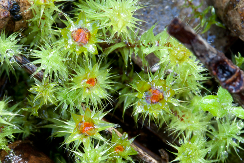
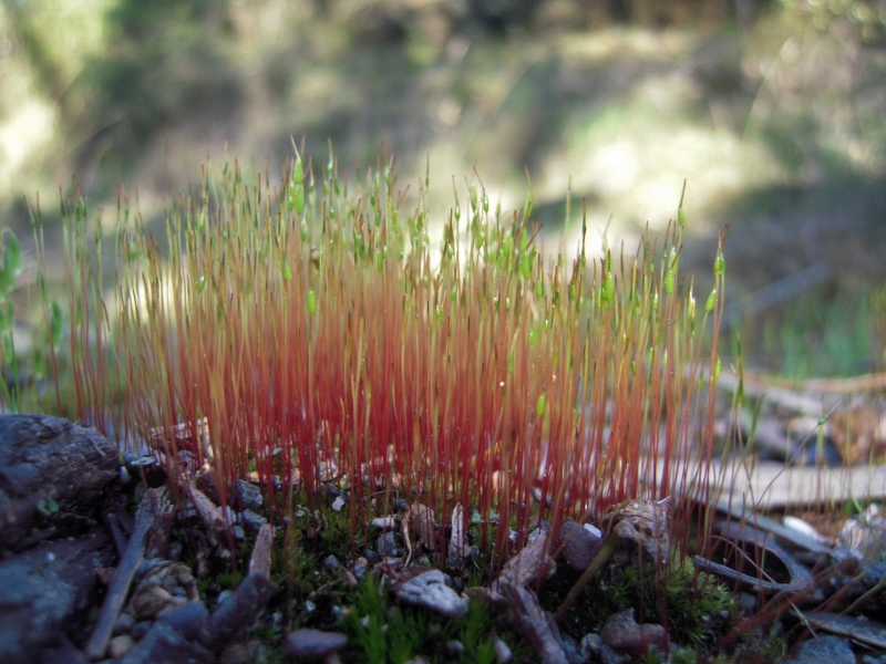
But by far the most prolific forms of life in the bush at the moment are the mosses and lichens, forming curious carpets and even aerial displays almost everywhere. The pics below show lichens of the Cladonia genus which form part of a group known loosely as squamulose: that is, they don’t cling to the surface, but send out independent, definitely three dimensional bodies off leaf like bases called squamules. Cladonia are normally found in damp, sheltered spots:

Cladonia sp, Smutta's Track: they don't look much from a distance, but have a strange fascination if you get down on your knees for a close up look. Photo: Bernard Slattery

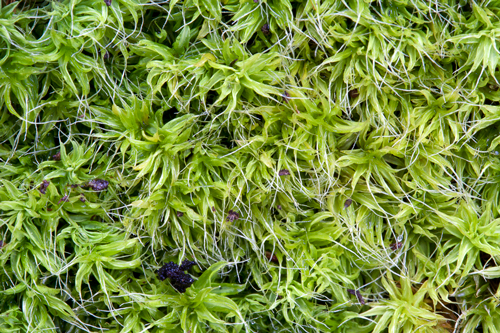
Another three dimensional group are called ‘fruticose’. An example is the Usnea genus, or ‘beard lichens’, which can be seen on dead and even living twigs around our bushlands:

Usnea sp, 'beard lichen', Tarilta gorge July 29, 2011 Photo Bernard Slattery

The microscopic strangeness of these combinations of alga and fungus should not blind us to their importance: they play a crucial role in creating and binding soil. On a more mundane level, lichens are indicators of air quality: they take in nutrients directly from

Continue reading

Posted in Nature Observations | Comments Off on Pollution monitors

Beautiful weeds

The lovely foliage in the picture below belongs to the Cootamundra wattle, Acacia baileyana, which is in prolific flower in our region this month.

Unfortunately, the Cootamundra is a good example of the rule that most weeds are quite beautiful. The problem with weeds isn’t that we don’t like them, it’s that outside of their native environment they become botanical bullies, displacing local plants and creating a less healthy environment.

Acacia baileyana, Poverty Gully Race, July 25 2011: a native of southern NSW, this tree is a weed in our region--but it's not the worst. Photo: Bernard Slattery

The Cootamundra is a minor player on our weed scene, however. The big villains in our part of the world include blackberry, gorse, boneseed, willow, bridal creeper and others in the category ‘Weeds of National Significance.’ Local groups, including FOBIF, Parks Victoria, Landcare and the Friends of Kalimna Park, have been active in trying to combat these pests.

You can find more info about local weeds and ways to fight them in the Catchment Management Authority’s just published North Central Invasive Plants and Animals Strategy 2010-2015.

This document naturally aims at eradication and control. It does acknowledge, however, that some weeds are well and truly out of control, and these cases adopts a policy of trying to protect ‘priority areas’. The only area thus nominated in our region is Mount Alexander State Park.

The document also sensibly puts community involvement as a key goal: it’s important for locals to be able to recognise weeds, and ‘have opportunities to participate as partners in all aspects of invasive species management.’ This is the point we were making in our post of July 20 on broom infestation on Mount Alexander.

The Strategy can be found online at www.nccma.vic.gov.au


Posted in News, Weeds | Comments Off on Beautiful weeds

More than wildflowers

Two FOBIF members recently visited the south end of the Castlemaine Diggings National Heritage Park to see what was in flower. Common Heath Epacris impressa in its pink and white forms was everywhere.

Common Heath. Photo by Bronwyn Silver

Downy Grevillea Grevillea alpina, Bushy Needlewood Hakia decurrens and Rough Wattle Acacia aspera were also in flower.

We spent some time observing a Black WallabyWallabia bicolour that was browsing on a Bush-pea shrub next to Porcupine Ridge Road and also found a profusion of bright orange Bracket Fungi Pycnoporus coccineus growing on a fallen log next to the Wewak Track.

Black Wallaby. Photo by Bronwyn Silver.

Bracket Fungi. Photo by Bronwyn Silver.


Posted in Nature Observations, News | Comments Off on More than wildflowers

Nuggetty Walk

Thirteen people braved the cold, foggy and wet conditions on the July FOBIF walk to the Rock of Ages. This magical site is situated on top of Mount Moorul which is a couple kilometres north of Maldon. It is part of the Nuggetty Ranges.

Some of the walkers on 17 July. Photo by Bronwyn Silver

At first fog prevented us from seeing the normally magnificent views from the summit. However the weather cleared and while walking along Nuggetty Track you could see north for miles. The Hedge Wattle Acacia paradoxa pictured on the right in the photo below was growing throughout the area.

View from Nuggetty Track, Photo by Bronwyn Silver, 21 July 2011.

Miles Geldard led the walk and provided an entertaining and informative commentary about the geology of the area and its fauna and flora. Two of the few plants in flower were Purple Coral-pea Hardenbergia violacea growing on granite bolders on the Rock of Ages and Small-leaf Clematis Clematis microphylla.

Purple Coral-pea. Photo by Genis Wylde.

Small-leaf Clematis. Photo by Genis Wylde.

Rock Ferns Cheilanthes sp. had clearly benefitted from months of regular rain.

Rock Fern. Photo by Bronwyn Silver.

Posted in Nature Observations, News | 1 Comment

CMA responds on creek clearance

At the FOBIF AGM a question was put to the Catchment Management Authority’s Damian Wells about vegetation clearance along Barkers and Campbells Creeks. We’ve had the following response from the CMA this week:

‘The CMA inspected sites in the region in response to community/stakeholder enquires following flood events.

‘Any sites that contained accumulated flood debris i.e. loose vegetative material such as sticks, logs, branches, leaf material were targeted for removal. At almost all blockage sites the accumulated flood debris was positioned against in stream ‘live vegetation’, therefore it actually was contributing to the blockage. Predominately, this in stream ‘live vegetation’ consisted of exotic vegetation, mainly willow but may have included hawthorn, ash and poplar species.

Campbell's Creek, July 2011: the stumps visible here are willows; the CMA says its works have had a 'negligible' effect on native vegetation.

‘At some sites live native vegetation (canopy) species such as red gum and wattle were amongst the accumulated flood debris sites. Therefore the act of accessing and removing the debris and live exotic species at the identified blockage sites with large mechanical machinery was unavoidable.

Continue reading

Posted in News | Comments Off on CMA responds on creek clearance

Broom attack on Mount Alexander

FOBIF members in April alerted Parks Victoria to the existence of a substantial and dense clump of English Broom on the east side of Mount Alexander. We had not previously noticed this pestiferous weed on the Mount, although it is infesting large areas of Victoria, including the goldfields. Parks staff subsequently sprayed the outbreak, with some effect, as the photos show. Having revisited the site in July, we believe that it will need another attack.

Broom outbreak on Mount Alexander, April and July. The clump is dense but confined, and can still be controlled with appropriate vigilance.

English broom was imported to Australia as a garden hedge early in the 19th century, and is now a declared noxious weed because of its ability to smother native vegetation and reduce agricultural productivity. It’s another example of the problematic effect of gardens on the Australian environment: garden escapes account for 65% of Australian environmental weeds, which cost around $4 billion a year in lost production and control costs. Given the location of the Mount Alexander infestation, we strongly suspect it is a result of dumping of garden waste.

This case illustrates the importance of early attack on weed infestations. In our view, one more year would have seen this limited outbreak impossible to control. Parks Victoria have assured us they will re-treat the area ‘as soon as possible’.

Posted in News, Weeds | Comments Off on Broom attack on Mount Alexander

Floods: keeping ‘out of harm’s way’

The North Central region had between four and seven times its long term rainfall average in January this year, and Castlemaine had five times its long term average. The rainfall between September and January was unprecedented, and came into an already wet catchment.

These figures formed the background to the talk given by Damian Wells, the CEO of the Catchment Management Authority to the FOBIF AGM on Monday night.

Flood damage was the theme of the talk, and there were two recurring issues:

The first was: it’s better to have assets ‘out of harm’s way’ than to have them in flood plains where they have to be protected.

The second was the flack copped by the CMA over its alleged neglect of waterways ‘causing’ the floods. Members will remember that this note was struck in Castlemaine, when it was claimed in the local press in January that plantings along creeks, or failure to clear creeks of vegetation, had raised flood levels in the town. [See our post of May 13]

Muckleford Creek over Lewis Rd, September 2010. The floods have been a boon ecologically, but although Victoria had eight major floods last century, Councils do not have adequate maps of flood levels. So building continues on flood plains. Photo: Bronwyn Silver

On the first issue, Damian noted that town levies are the responsibility of councils, but that rural levies protecting property are a long standing maintenance problem and the source of continual disputes as to who is responsible for them. The lower Loddon has 200 kilometres of levies, and these failed in 117 places in January. It has been estimated that restoration of levies could cost $650 million. He praised the government’s offer to buy out farmers in vulnerable areas, as a more practical long term solution to inevitable floods than prohibitively expensive protection measures.

On the second theme, Damian noted that the CMA had been ‘howled down’ in Creswick for its supposed responsibility for floods there, but subsequent investigations had completely vindicated its position. Bridges and road culverts are major causes of water blockages and subsequent level rises, but the major problem is building on flood plains. The CMA is continually challenged by developers in VCAT when it opposes building in such areas.

He agreed that peak flood level models should be incorporated into planning schemes on a state wide basis, to avoid the situation of people building on flood prone land. Incredibly, he noted that current modelling of flood risk zones is inadequate. [In spite of the fact that Victoria had serious floods every 10-20 years in the last century— in 1909,1916,1917 1974 1956 1974, 1990, and 1993— it seems we still don’t have good maps telling us where not to build!]

Continue reading

Posted in News | Comments Off on Floods: keeping ‘out of harm’s way’

Reports come flooding in

Coincidentally, the Comrie Report on the 2010-11 floods has just been released. Although the report concentrates on the performance of emergency services, it does contain some enlightening remarks which underline Damian Wells’s  argument. For example:

‘It is important to understand that the application of appropriate land use planning controls as part of municipal planning schemes is considered to be an effective means of minimising flood damage. Municipal councils are required to take into account flood risk when considering appropriate development on floodplains.’ [page 6]

Expedition Pass spillway, January 2010. The sheer volume of water guarantees that flood plains will flood. Repeated enquiries have urged tighter building controls on floodplains, to minimise asset damage. Photo: Bernard Slattery

The Comrie report makes reference to a document with which we were not familiar: the 1998 Victoria Flood Management Strategy. This document, currently under revision, is available here

Among other things, the Strategy says

‘Appropriate land use strategies are the most effective means of reducing the growth in flood risk and damages. With the introduction of Victoria Planning Provisions [VPPS], the ability of Victorian councils to carry out their land use planning role will be strengthened. The VPPs provide uniform statewide policy and control for development and works on floodplains. They require that flood risk must be considered in the preparation of planning schemes and in making land use planning decisions, and that land affected by flooding must be shown on planning scheme maps.’ [Page 9]

It seems from the substance of Damian Wells’s talk to the AGM that this has not happened.

The Parliamentary Environment and Natural Resources committee is due to present a report on the floods later in the year.


Posted in News | Comments Off on Reports come flooding in

FOBIF Elections 2011

At the AGM on Monday July 11, Public Officer Chris Morris announced that the following nominations had been received before the meeting:

President: Marie Jones

Vice President: Nev Cooper

Secretary: Bernard Slattery

Treasurer: Bronwyn Silver

Committee Members: Frank Panter, Kylie McIndoe

As the number of nominated candidates equalled the number of positions on the committee, according to the Constitution, the above were declared elected.


Posted in News | Comments Off on FOBIF Elections 2011

What’s happening up at Morgan’s Track?

The rather sad sign below is a marker on Morgan’s Track Chewton of the Ecological Thinnings Trial conducted by Parks Victoria beginning in 2003.

Despondent sign at Morgan's Track, July 2011: we hope that ongoing research on this trial will prove valuable. We have been assured that the research continues. Photo by Bronwyn Silver

The trial was proposed by the Environment Conservation Council when it recommended the establishment of new Box Ironbark reserves in 2001. The intention is to experimentally aim at the restoration of a pre white settlement forest structure by strategically thinning selected plots in the aim of getting a woodland of more widely spaced, larger trees, and a healthier, more diverse understory. In fact, our woodlands are on the whole gradually thinning themselves as weaker trees die: so the trial is an effort to speed up the work of Nature.

FOBIF did not oppose the trials, even though we thought that in our region they were misconceived, and the money and resources could have been better spent elsewhere—on weed control, for example. We did concede, however, that the accompanying monitoring and research could prove very valuable for our understanding of these ecosystems. For a more detailed account of our views, you can read an item from our 2008 newsletter here.

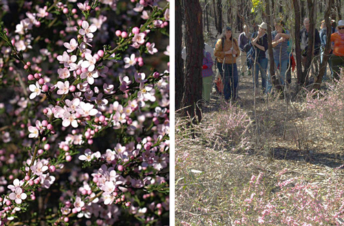
FOBIF members did a prowl around the Morgan’s site on July 8. This area has always been rich in wildflowers, and it looks like the coming spring will not disappoint. Even in the dead of winter there’s plenty to see, as the pictures show.

Even in the dead of winter, there's plenty to see at Morgan's Track. Photos by Bronwyn Silver, July 2011

And the effect of the trial? Monitoring up to 2008 cautiously suggested that the thinning had up to that point been positive in encouraging understorey diversity.

Continue reading

Posted in News | Comments Off on What’s happening up at Morgan’s Track?