How do they do it? [2] Surviving in the pollution soup

The picture below is a Common Long Neck turtle [Chelodina longicolis] sun baking in the horrible pollution soup that is Forest Creek at the Wheeler Street bridge. Turtles have been seen in this unpromising location for many years, and seemed even to have survived the millenium drought, when there was little or no water under the bridge.

Common long neck turtle in Forest creek: it's not the most pristine environments, but the species has hung on in this location for years.

Common long neck turtle in Forest creek: it’s not the most pristine environments, but the species has hung on in this location for years.

The scum covering the turtle’s back doesn’t suggest that the creature is terribly healthy, but when disturbed, it moved with tremendous speed to take shelter in the reeds.

Interesting turtle facts: the Common Long Neck [aka ‘snake neck turtle’ and ‘stinker’] can survive long dry periods by digging into soil and aestivating. According to the Bendigo Field Naturalists excellent guide Frogs and reptiles of the Bendigo district, ‘turtles communicate with each other via a wide range of vocalisations that have a lower pitch than humans can hear.’ When threatened, the turtle lets out an offensive odour [hence the unromantic name, ‘stinker’]. This turtle can live for 50 years, so maybe the sightings regularly made in this unpromising location over the last 20 odd years have been the same one.

This creature can wander significant distances in search of viable habitat. And guess what? After habitat depletion, the biggest threat to its survival is that of being run over by a car.

Posted in Nature Observations | Comments Off on How do they do it? [2] Surviving in the pollution soup

‘Risk management’: what does it mean, in practice?

The recently abolished ‘five per cent target’ policy aimed at burning at least 390, 000 hectares of public land per year.

This target was never reached, and was probably never going to be possible. In the last five years, the highest annual total was 250,542 hectares burned.

Under the new ‘risk management’ policy [see our post below], bushfire management will still be heavily concerned with fuel reduction burns on public land:

‘From 1 July 2016, our fuel management program on public land will be driven by a state wide target to maintain bushfire risk at, or below, 70 per cent of Victoria’s maximum bushfire risk. Based on the current assessment of risk, this will involve treating between 225,000 and 275,000 hectares in 2016-17.’ [Page 13, Safer together]

In other words, there’s still a target, and it’s about the same as now.

As we’ve pointed out before, recent documents on fire have been very keen to tell us that fuel management is ‘only one’ of several approaches to bushfire control. For example: ‘Fuel management is just one strategy for reducing bushfire risk…Beyond planned burning, we take many other actions to reduce bushfire risk – slashing, mowing, creating fuel breaks and maintaining infrastructure like water points and lookout towers in our forests and parks. Other ways to reduce risk include positioning firefighters and aircraft across Victoria for rapid response to bushfires when they start, building standards for new housing, developing neighbourhood shelters, issuing community warnings and coordinating evacuations.’ [page 8, Safer together]

There are also challenges around prevention [arson, for example], and issues to do with housing development in bushland.

Unfortunately burning is the approach that gets heavy priority treatment.

And fuel reduction on private land? On this, we have vague gestures about what will happen in the future [See below: Lessons from Lancefield 2].

Posted in Fire Management, News | 1 Comment

Lessons from Lancefield [1]: resourcing

The management burn which escaped from the Cobaw State Forest in October with disastrous results was the subject of an independent investigation led by Stuart Carter. His report was released last week. It can be found here.

We won’t comment on the report’s wider judgments, since we’re not familiar with the Cobaw area, but would like to highlight two of its findings, which we believe are applicable virtually anywhere in the state. The first is on resourcing:

‘Interviews [with DELWP staff] also revealed that there is a resignation by staff that district resources and budgets are tight and this may result in resources at a burn being “thin”. The Investigation Team noted that many of the staff interviewed commented that the resourcing for the  Lancefield-­‐Cobaw  burn  was not optimal however “we do what we can with what we have” or “we are just used to managing with what we have”.’

How many times have we heard a version of this? Policy and colour documents are fine. Too often they have been used to cover up what we are unfortunately used to: land management on the cheap.


Posted in Fire Management, News | Comments Off on Lessons from Lancefield [1]: resourcing

Lessons from Lancefield [2]: public land, private land

A second point worth highlighting in the Carter report is the importance of integrating public and private land in fire preparations. The report says: ‘The Department must adopt a tenure-­‐blind approach to the management of bushfire risk including the planning of  burns.’

In the case of Cobaw:

‘A common response from some [DELWP] staff interviewed who had responsibility for planning part of the burn was that in spring the surrounding area was green paddocks, but in reality this burn is surrounded by public and private forest, much of it long unburnt. The burn plan contains little information about the surrounding area, the fuels outside the burn, neighbours and the broader context. It will be stated throughout this report that the focus of the Department in relation to the Lancefield-­‐Cobaw burn was clearly on its own tenure with inadequate attention to external considerations. The Investigation Team does however note that processes are afoot to shift bushfire risk management, and therefore burn planning, to a broader landscape approach… This will provide some impetus for change however significant cultural and procedural shifts within the Department are also required to increase the focus on external factors and contingency planning.’

The policy of integrating public and private land into bushfire plans is still undeveloped, as we’ve pointed out before. The Safer together document [see below], while enthusiastically embracing the idea of private participation in bushfire mitigation, has this to say:

‘While our bushfire risk target will only apply to the delivery of the fuel management program on public land in the immediate term, we will build our systems and processes to enable a bushfire risk target to guide planning and investment across all bushfire risk reduction activities on public and private land in future.’ [p 13] [Our emphasis]

In other words, ‘processes are afoot’, but as for action: not yet.

The risk we run is that the ‘new’ policy will look very like the old one.

Posted in Fire Management, News | Comments Off on Lessons from Lancefield [2]: public land, private land

‘Five per cent’ topples at last

The State Government has finally accepted the recommendation of the Inspector General for Emergency Management to scrap the policy of burning five per cent of public land each year. The government will instead pursue a risk assessment policy.

The new policy is outlined in a 20 page colour document entitled Safer together: a new approach to reducing the risk of bushfire in Victoria. It can be found here.

The new approach will be delivered in three stages. DELWP expresses it as follows:

‘ · From 1 July 2016, the Government will apply a risk reduction target
for fuel management on public land.
‘ · In 2017-18, land and fire agencies will partner with communities to
manage fuel loads across public and private land in the highest risk
areas.
‘· Ultimately, we will apply a risk based approach to all bushfire
management strategies, working as one fire management sector, so we
can invest in the most effective ways to reduce risk.’

The new policy is not a panacea for bushfire control, though it’s preferable to its unlamented predecessor. It’s significant that the policy has been announced on the same day that DELWP revealed that the Lancefield escaped reduction burn disaster was caused by a failure in risk assessment and resourcing. In other words, good decisions still have to be made, and their implementation still has to be properly resourced.

What are the prospects for the new Risk Assessment approach? We’ll have a look at this question over the next week.

Posted in Fire Management, News | Comments Off on ‘Five per cent’ topples at last

“Mum look out, don’t touch!”

A recent visit to our local patch and bush cubby saw a near miss for me and the realisation that the bush in Campbells Creek seems in distress. On our way up the trunk of our unusual, almost horizontal Candlebark ’friend’, my daughter said, “Mum look out, don’t touch!”

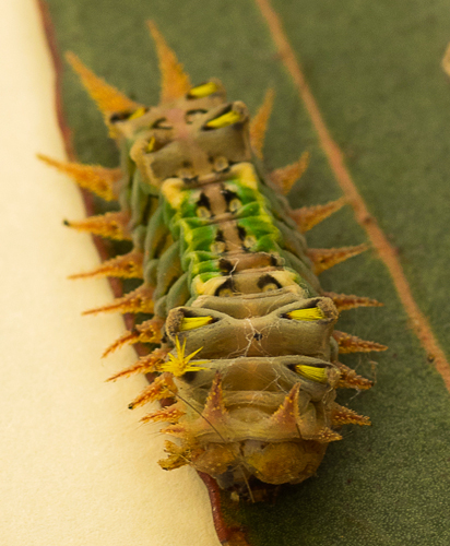
Her six year old eyes, sharper than mine, had spotted a Cup Moth caterpillar or Doratifera sp.

She was right in warning me, the caterpillars, often known as ‘stingers’ or ‘stinging joeys’ have  spines that can inflict a sharp and painful sting, rather like a nettle. When I looked around I noticed there were many caterpillars of the same species heading up the trunk and into the canopy, which appears much more open than usual, presumably they were heading for lunch.

Cup-moth

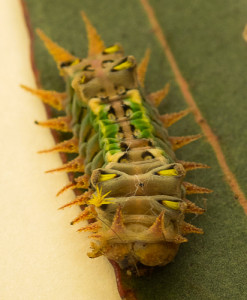
Cup-moth caterpillar. Photo by John Ellis

Cup Moths are forest insects and at times have been responsible for severe damage to Eucalypts in Victoria. Sometimes they also become pests on garden trees, especially fruit trees such as apricots, apples and cherries. Back in August 2012 FOBIF reported finding the Cup Moth in a large tract of defoliation in the south end of the shire.  

Cup moths belong to a small group of moths that have unusual slug-like caterpillars with clusters of spines on their bodies that are often beautifully marked and coloured. Their name comes from the cup shaped cocoons made by the caterpillars when they pupate.

Young caterpillars feed by skeletonising the leaves while older caterpillars eat the whole leaf often leaving only the midrib.

defoliated-trees-along-the-Castlemaine-Muckleford-Road.-IMG_0646

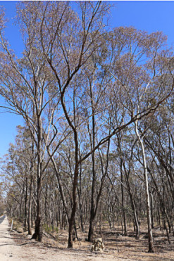
Defoliated trees along the Castlemaine-Muckleford-Road

It is the caterpillar (larval) stage that causes the damage. Many leaves are completely or partially eaten and many more are cut off and fall to the ground. Caterpillars are usually present in small numbers but sporadic outbreaks may cause severe damage with trees completely defoliated over a large area. However, unless attacks occur over 3-4 successive years the trees usually recover.  

Long time resident the late Doug Ralph responded to our 2012 post by recounting an outbreak ten years prior and a long break in occurrence in between. These recent attacks coupled with the very dry weather though may have a more serious effect on the health and survival of the trees.

Cup Moth caterpillars are very susceptible to viral diseases and sometimes entire populations are killed. Viral disease is the most common natural control of Cup Moth caterpillars. Outbreaks of disease usually occur when weather conditions are warm and humid and when there is overcrowding and shortage of food. Affected caterpillars stop feeding and the body swells with the body contents liquefying and the skin eventually splits and releases the contents over the leaves. Other caterpillars can then become infected.

Natural predators can include parasites, wasps, flies and occasionally, birds.

It is distressing to see the damage done by these animals. Coupled with an asset protection burn and drier weather, the bush in our patch at Campbells Creek seems to be really up against it. I wonder what changes my daughter will see as we continue to visit our cubby into the future.

This post was written by Naomi Raftery with most of the factual detail provided by Marie Jones. If readers have any further information on cup moths or would like to share their stories of personal encounters with them we welcome contributions.

Posted in News | 1 Comment

Befriending our frogs

Elaine Bayes and Damien Cook who led our last FOBIF walk in Chewton have produced two terrific youtube videos:’Frogs and their Calls’  and ‘Frogs and their Habitats’. The information is well presented and relevant to our local area. Each goes for about 30 minutes. Click on each image below to view.

Elaine

Damien

Posted in News | Comments Off on Befriending our frogs

Geology excursion this Saturday

Muckleford Landcare has organised an excursion for November 14 which will take in Mount Gaspard and the Muckleford Gorge. FOBIF members might remember a fascinating walk we had in the Muckleford Gorge in 2011. The following text is taken from the Muckleford Landcare website:

There are still a few places left on the bus next Saturday for our geology excursion.

This should be a fascinating and revealing experience. Our first stop will be the summit of Mount Gaspard at the north of the valley. Mount Gaspard is on private land and the view is immense. Thanks to the generosity of the Huzzey family we will have access to a spectacular panorama of the whole valley and its larger geological setting.

We will travel down the Chinaman’s Creek valley until it connects with the main Muckleford valley and then follow the famous and significant Muckleford Fault south until we conclude our journey at the Muckleford Gorge. Once again we will have access to private land to view this beautiful and surprising place and for that privilege we thank the Garsed family.

To find out more about the day click here.

Frank Forster took this image of the Muckleford Gorge on the FOBIF walk in 2011. Due to the current drought we are unlikely to see much flow this year.

Frank Forster took this photo of the Muckleford Gorge on the FOBIF walk in 2011. Unfortunately with the current drought we are unlikely to see much flow this year.

Posted in News | Comments Off on Geology excursion this Saturday

Reprieve for ‘The Big Tree’

The Guildford Progress Association has received news that their concerns about the proposed work on The Big Tree have been heeded. The following is an excerpt from a recent letter to the Association from the Shire:

Due to the continued concerns of the Guildford Progress Association regarding the arboricultural works proposed by Council on “The Big Tree”, I wish to inform you that these works have been postponed.

 Council has commissioned an independent arboricultural assessment of the tree.  The consultant will provide Council with a report and any recommended works.  I will ensure that the Guildford Progress Association is kept informed of any intended works on or at the site of “The Big Tree”.

We will keep you informed about any further developments on this issue.

Posted in News | 1 Comment

Heritage: um, what about us?

Whatever its merits, VEAC’s draft report on heritage places is notable for one baffling deficiency: its failure to consider landscape as a heritage ‘place’. More specifically, it’s clear that the Castlemaine Diggings National Heritage Park is considered, in this report, to be a collection of mining sites, not a landscape.

How can we tell this?

Table 2.2 of the document lists heritage places by type. ‘Landscape’ is declared to have only one sample of this type. What is it? To find out, we go to Appendix 2, where the only example listed is Tower Hill State Game Reserve.

How has VEAC, whose responsibility has largely been in environmental matters, managed to exclude landscape from its considerations?

The answer is to be found on page 30, in a discussion of Indigenous views:  ‘It is important to note that although VEAC’s focus is on the management of specific places on public land, Traditional Owners customarily have a broader view that every part of the landscape is of significance, including landforms and the whole landscape itself, not only those places where associations are evident or documented.’

It seems that VEAC hasn’t been able to adopt something like this broader view itself. It looks like the Diggings Park, as a landscape, has slipped into the too hard basket.

This is a curious deficiency. The Park is described by Parks Victoria as ‘the largest non-indigenous protected cultural landscape in Australia.’ Its National Heritage listing, bland though it is, offers this: ‘Situated within regenerating box-ironbark forest, the mining remains and habitation sites immediately convey to the visitor a feeling of passed [sic] ways of working and living. The great number and extent of remains reinforces to the visitor the historical significance of the goldfield. The degree of alteration of, and intervention in, the natural landscape makes a strong impression on visitors. The Castlemaine diggings are a place of strong aesthetic significance. The attributes include the wide expanses of regenerating box-ironbark forest, the landforms of hills, ridges, gullies, creeks and rivers, together with the multitude of mining and habitation remains…’ The Victorian Heritage listing says: ‘The land and its regenerating Box-Ironbark forest is important scientific evidence in its own right in demonstrating a spectacular event of transformation of the pre-gold rush environment.’

Why does all this matter? Continue reading

Posted in News | 1 Comment