Here are a few details from the SOE report, relevant to our own region:
1. Paying attention to good on ground management matters.
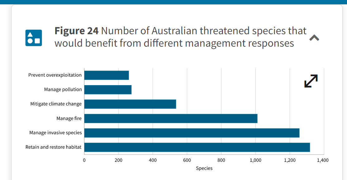
If you ever wonder whether Landcare is worth the effort, or if weed and feral animal control matters, check this table:
2. Amazing news—it’s getting dryer!
‘Infrastructure Australia’s 2019 audit found that the reduction in average winter rainfall in south-western Australia has caused a 50% reduction in urban run-off over the past 50 years, leading to declining streamflows across the southern and south-eastern regions.’
3. Urban design matters, and so does the greening of our towns and cities
‘Because of the increasing ratio of building area to land area on lots, the space for trees, plants and outdoor recreation at both the front and rear of dwellings has declined. This change in urban form is not only changing the physical form and character of existing and greenfield neighbourhoods, but the ability to manage heat, improve walkability and thereby the livability or our urban environments. It is also reducing the extent of urban biodiversity by decreasing tree canopy cover and garden space… Research has found that private sector residential development in the past 20 years has less tree cover than in previous decades…
‘… To manage urban heat and increase our safety and wellbeing, we will be looking to re-establish more natural environments within our urban environment, empower Indigenous peoples and their knowledge, create new programs of tree planting, reintroduce biodiversity, renaturalise our waterways and use biomaterials to construct our built environment. This must occur concurrent with our reduction in energy consumption and as we reconnect our green and blue urban infrastructure into a quality network for people and urban biodiversity.’
- Guess what: offsets may not be such a great idea…
‘The growing dependency on offsets to protect matters of national environmental significance from the impacts of development is risky, given the lack of demonstrated successful outcomes, and inadequate monitoring and oversight.’ [FOBIF emphasis]
- Settling people in fire prone environments has big consequences
‘In a post-pandemic digital era, modern settlement patterns are likely to proliferate across rural and regional Australia as more people are less tied to working in large cities … Managing a more distributed network of people with exacerbated fire weather across whole landscapes is likely to have significant negative consequences for vulnerable biodiversity and ecosystems, with flow-on impacts to natural capital and diminished resilience of local communities. Local communities will need to revisit the objectives of their fire management strategies to balance the potential human impacts with natural capital values they wish to maintain.’
- Way to go: indigenous solutions
An interesting feature of this report is its heavy emphasis on the need to pay attention to indigenous ways of thinking and managing. It is extremely positive about the increasing engagement of indigenous people in land management, but offers the following sober reality check:
‘Indigenous people are rich in land assets and poor in terms of access to finance and other critical support to manage Country. The Indigenous estate has grown through native title determinations and other means. However, recognition of Indigenous ownership or land-use agreements does not automatically translate to Traditional Custodians accessing, actively managing and realising wellbeing and economic benefits from their lands.’
- And here’s a provocative claim
‘Historically, planning regulations have put the protection of people first, the protection of assets second and the protection of the environment third. This has downplayed the wellbeing implications of connections between people and the environment, which has particular implications for Indigenous people’s connections to Country.’








 Click on image for info/order page
 Click on image for info/order page
 Click on image for info/order page







