A lot of fires are being lit, but what’s being achieved–and how would we know?

Bendigo region conservationists, including FOBIF, met with DSE officials last Wednesday April 18th,  to discuss current and future fire operations.

The meeting did not discuss State Government fire policy. It was solely concerned with the implementation of this policy, in the light of conservationists’ dissatisfaction with the way burns are being conducted.

The objectives listed below were put to DSE officers at the meeting. They would require managers to be very precise in their burn plans about how they will manage key risks and how they will take into account community submissions. They would also require the publication of clear assessments of each burn in the light of the plans:

Objective 1 DSE to provide detailed mapping of each burn parcel, as listed in Appendix B of the Code of Practice, to identify a broad range of regionally specific ecological values.
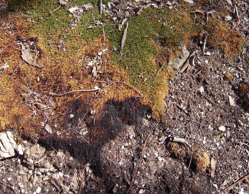
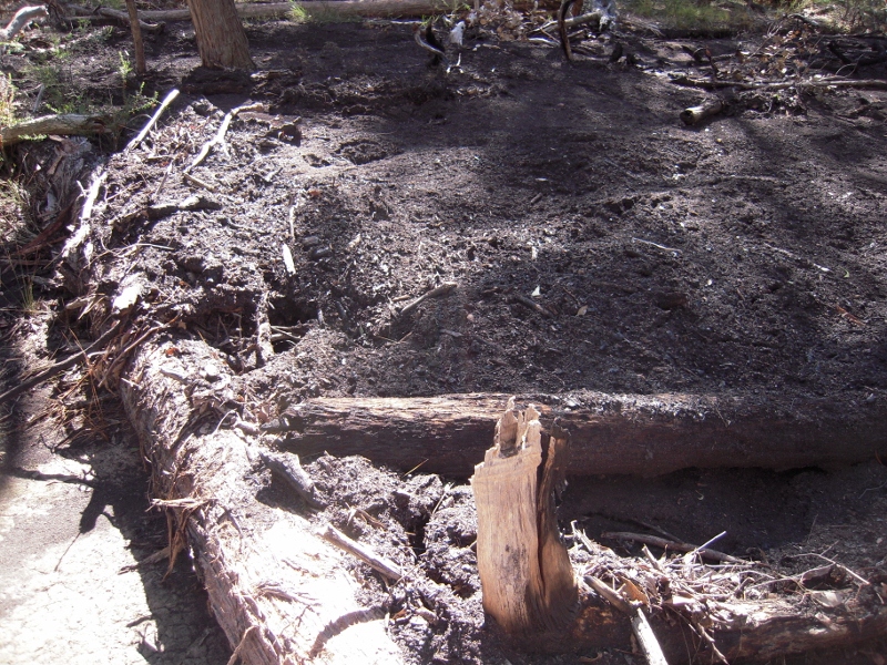
Burned moss patch, Muckleford State Forest, March 2012. Moss is not flammable, and is sensitive to fire. It performs a valuable role in forming crusts which protect land from erosion and soil loss. Prescribed burns which destroy such patches do not reduce fuel, but they do damage the bush. Conservation groups in Bendigo want DSE to specify what its objectives are in burns--and to be open about what they really achieve.

Objective 2DSE to provide detailed fuel load mapping for each burn parcel and across each Fire Management Zone.

Objective 3To ensure the expectation for adaptive management in the Code of Practice is met, DSE to provide detailed responses to community Fire Operations Plan input, accurately describing how this has been incorporated within the approved burn plan.

Continue reading

Posted in Fire Management, News | Comments Off on A lot of fires are being lit, but what’s being achieved–and how would we know?

April FOBIF walk

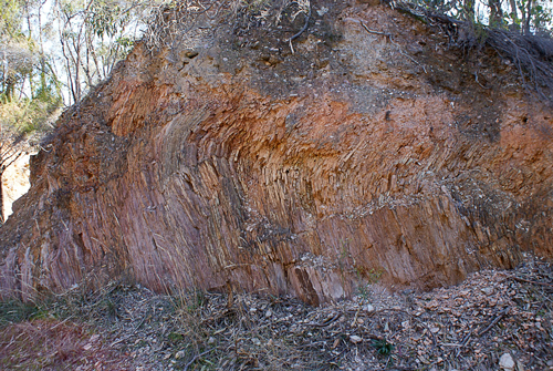
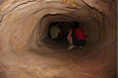
Forty-one walkers set out from the Garfield Water Wheel in Chewton on Sunday on the second FOBIF walk for the year. Local geologist, Julian Hollis led the walk and everyone appreciated his explanations of the significant geological features in the area. The highpoint of the walk was Quartz Hill where people could explore a 30 metre mining tunnel and see other evidence of local mining which dates back to 1852.

Thirty-Metre Tunnel, Quartz Hill. Photo by Dominique Lavie, 15 April 2011

Sliding Fold, Quartz Hill. Photo by Frank Forster, 15 April 2012

More photos of Quartz Hill and surrounds can be found on Dominique Lavie’s Facebook page. An interesting history of mining activity at Quartz Hill can be found here.

FOBIF’s next walk on 20 May will also be in Chewton. It will include the Monk and a circuit taking in Cobbler’s Gully, the Herron’s Reef diggings and possibly the Crocodile reservoir.

Posted in News | Comments Off on April FOBIF walk

Tarilta: ecological burning in question

We have received a second reply from DSE’s Paul Bates on the subject of the Tarilta management burn [see below]. In addition Ewan Waller, DSE’s Chief Fire Officer, fielded questions on the subject on ABC radio on Friday March 30. On the same day, the Bendigo Advertiser carried an item on the matter featuring a statement by DSE North West Regional Manager John Rofe to the effect that ‘the aim was to reduce the threat of fuel sparking a bushfire’.

The gist of all of the above is clear.

  1. The stated aim of the Tarilta exercise [in the DSE zoning system, the Bendigo fire plan and on the DSE website] was to achieve an ecological outcome [see our post]. The statement by John Rofe in the Advertiser, and the evasions of Ewan Waller, make it clear that ecology has nothing to do with it. The aim is to burn the bush, and it’s not too strong to say that this was done without the slightest consideration for ecological values.
  2. It’s blindingly clear that no notice was taken by DSE of warnings that burning steep slopes before heavy rain will bring about an erosion event. Either this is because DSE, as a land manager, doesn’t think soil loss is important, or it is because the Department is so driven by its burning targets that it thinks only of burning hectares.

One of the less steep drainage lines in the Tarilta gorge area: this soil has been washed off the hilltops.


3. It’s clear that DSE has no control over what happens inside its control lines. In other    words, the idea of ‘cool burns’ is a very slippery one, as is that of ‘mosaic burns’, where patches of burned and unburned ground alternate.

4. It’s also clear that the objective to burn an area classified as a particular Ecological Vegetation Class is not based on any real knowledge of what might or should happen in the area in question. FOBIF urged DSE to consider carefully the effects of the adjacent 2010 Wewak track burn before proceeding with this one. It’s London to a brick that no such consideration was given.

Paul Bates letter is given below. We have interpolated our questions in italics:

Continue reading

Posted in Fire Management, News | 1 Comment

Fire: who knows how to use it?

DSE Chief Fire Officer Ewan Waller claimed on ABC Radio on March 30 that one of the aims of his department is to create a ‘pre European’ forest structure by using fire. This seems to suggest that he is familiar with pre European fire regimes. We’re not sure what these regimes were in our area, but it’s worth brooding on one recent effort to describe them.

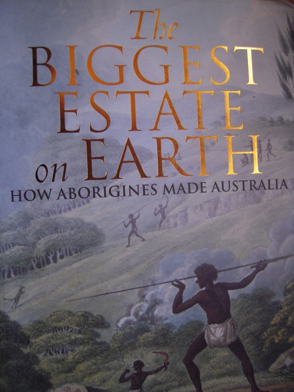
In his book The Greatest Estate on Earth [Allen and Unwin 2011] Bill Gammage argues that Aborigines used fire not as a simple survival tool, but as a sophisticated means of shaping the environment: and that they made Australia a ‘farm without fences’ with it, a place frequently referred to by early white settlers as ‘a gentleman’s park’.

Gammage argues that Aborigines used fire throughout the continent, but the picture he creates of indigenous methods of burning provides an interesting contrast with the kind of massive, blunt and destructive exercises we are seeing today. In brief:

–Aboriginal groups had territories they understood in intimate detail.

–their burns were small scale, modified for different species patterns, conducted with an expert eye on the weather, and controlled. Although he doesn’t discuss practices in our area, he mentions, for example, that in the Western Desert, most patches burnt were ‘less than five hectares.’ This contrasts dramatically with the hundreds of hectares being burned around here, and the thousands being done at a time in the Mallee.

–They managed their territories in varying degrees of intensity depending on use, spiritual significance, etc

–Management included long periods without fire for some areas [eg, no burning for ‘generations’] if that is what they perceived the country as needing.

–They were conscious of shape, topography and access, and burned diligently at, say, forest edges, clearings, access routes.

–Aborigines timed ‘most [not all] fires to go out at night: overnight fires could confess loss of control’.

–They very rarely killed mature trees with their fires.

Continue reading

Posted in Fire Management, News | Comments Off on Fire: who knows how to use it?

DSE answers on Tarilta fire

Last week FOBIF secretary Bernard Slattery wrote to DSE Bendigo to express our concerns about Tarilta Gorge, in particular the massive soil loss resulting from the Department’s management burn [see our post].We’ve received the following answers to our questions from Paul Bates,Forest Manager, Bendigo Forest Management Area. For convenience of readers, we’ve put our questions in italics before each answer. Readers can assess whether our questions have been answered:

1.     Last year in our submission on fire zones we drew attention to the steep slopes in this area, and the need to be extra careful in any burning operation. Given that heavy rain was predicted in the week after the proposed burn, why was there evidently no effort to protect the steeper slopes? [Sludge in the creek is up to a metre deep in parts. In walking along the creek bed I went up to my waist at one point in soil and ash]

DSE: ‘DSE monitors fuel and weather conditions when completing prescribed burns. The weather records over the days when this burn was ignited show that the conditions were within the limits for burning in this type of forest. DSE also monitors weather forecasts for the days following ignition of a prescribed burn including potential rainfall. Predicting accurate rainfall amounts and intensity can be difficult, especially predictions several days ahead. All weather factors are considered and a decision was made in this particular case that ignition of the burn area would proceed.’

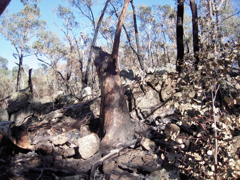
Destroyed candlebark, ten metres from Tarilta creek. We estimate that the tree was about a metre in diametre at breast height. Although it is hard to estimate its height, it may well have been the tallest tree in the valley [see additional photo below


2.     We’re still at a loss as to DSE’s inability to protect large trees from these burns. Red box on the slopes and even larger trees on the valley floor have been destroyed. We’d like to know what kind of supervision takes place in this area.

Continue reading

Posted in Fire Management, News | 4 Comments

What happens under the tractor?

The first public evening session in Connecting Country’s 2012 Education Program was attended by 75 people at Campbell’s Creek last week.

The talk was given by Dr Denis Saunders, who posed a set of question about the long term viability of agriculture in Australia. He discussed the curious fact that we know little or nothing about the effect of agricultural practice on soil micro organisms, and argued that ignorance on such matters might lead to long term bad practice. His theme, on the interdependence of people and environment, was stated as an acknowledgement of Aboriginal land management practices in the words: ‘we are country, country is us.’ A fuller report on the evening, together with info on the remaining sessions in the program, can be found here.

Posted in News | Comments Off on What happens under the tractor?

Tarilta questions

Following our visits to the DSE burn site in the Tarilta Gorge [see our post] we have written to DSE management in Bendigo seeking a response to the following questions:

1. Last year in our submission on fire zones we drew attention to the steep slopes in this area, and the need to be extra careful in any burning operation. Given that heavy rain was predicted in the week after the proposed burn, why was there evidently no effort to protect the steeper slopes? [Sludge in the creek is up to a metre deep in parts. In walking along the creek bed you can go up to your waist at one point in soil and ash]

2. We’re still at a loss as to DSE’s inability to protect large trees from these burns. Red box on the slopes and even larger trees on the valley floor have been destroyed. We’d like to know what kind of supervision takes place in this area.

3. The Ecological Management Zone’s purpose is ‘promoting biodiversity and ecological renewal. Planned burning will be used to manage native species and ecological communities which require fire to regenerate.’ Can you tell us which species you had in mind in this operation? Is there baseline data to enable an assessment of the success of the operation?

4. We were under the impression that in this zone the intention is to do a mosaic burn covering about one third of the area. It seems to us that much more was actually burnt. Can you tell us what your estimate is of the burn coverage?

We’ll post the reply as soon as it’s available.


Posted in Fire Management, News | Comments Off on Tarilta questions

Floods: taking a wider view

Every time there’s a flood, there seems to be an outbreak of simple suggestions about how the disaster might have been averted.  Some of these are more sensible than others, and even some of the more sensible ones–like, stay out of the flood plain, and you won’t be flooded–aren’t very helpful for people who, through no fault of their own, find themselves in flood prone areas.

There may also be a case for schemes to hold as much flash flood water as possible in areas of the catchment from where it can flow more slowly over a longer time into creeks and streams. Those who have been paying attention to the various reports arising from the Queensland floods will have noticed that the flash floods in Toowoomba might have been prevented had the local council spent money on holding basins in critical parts of the catchment. Old timers in Castlemaine tell us that such work was planned in the Poverty Gully area in the 1990s, but not proceeded with. A large part of the flash flood in Castlemaine came from a huge dump of water from the Poverty Gully catchment. Work like this costs money—but so does flood damage. Our environment is a degraded one, with very thin soil cover, where heavy rain runs off very quickly instead of being retained in the soil or held back by vegetation.

Readers might be interested in the reflections of ecologist Ian Lunt on the effects of water on degraded land:

‘Intact ecosystems are very good at retaining water. Falling rain hits ground plants and litter, and these slow the flow of water through the ecosystem. The more water that is held in the landscape, and the longer it is available, the greater the biological productivity.

Degraded landscape in the Campbells Creek catchment: Ian Lundt says that improving the capacity of landscapes to hold water could soften flood impacts.


‘By contrast, degraded dryland systems are very leaky. Degrading processes such as heavy grazing remove the plants and litter that intercept surface water. Water runs off faster and soils dry out faster, and this in turn, leads to further reductions in biological productivity. This creates a vicious cycle as ‘leaky ecosystems’ become more and more degraded.

‘To restore degraded dryland systems, arid zone ecologists focus on measures that slow the flow of water across the landscape. Understory and ground plants, fallen timber and leaf litter all create small barriers that prevent water from leaking, or running out of the system. Drifts of leaf litter on the ground improve water infiltration and soil condition (including organic carbon levels), so soils can store more water for longer.

‘In degraded dryland systems, a primary management goal is to improve the system’s ability to retain soil moisture.’

Ian’s full discussion can be found here.

Posted in News | Comments Off on Floods: taking a wider view

Floods: running to the past

Recent heavy rains in Victoria have brought about a return of calls to strip vegetation from waterways as a way of reducing flood levels.

The claim that vegetation along waterways raises water levels was raised last year when some locals blamed landcare plantings for flooding in Castlemaine. At the time FOBIF pointed out that creeks and streams had been stripped of vegetation for many years up to the 1990s. This practice had not solved the flood problems but had produced a few of its own, including, predictably, erosion of stream banks. It’s worth remembering that the shocking floods in the past came along streams entirely stripped of vegetation—the catastrophic 1889 event being the most infamous.

In our post we quoted Australian Land and Water research which showed that ‘Adding or removing large wood (snags) in streams has little effect on the height and duration of large floods.’ This is the consensus opinion of those who have looked seriously at the flood problem, but it has not stopped the State government from announcing that it would consider going back to the practice of ‘desnagging’ streams. It’s hard to believe that the government will proceed with a practice which so obviously failed, but we’ll have to wait and see.

In the meantime the Midland Express carried a front page article with photo on March 6 showing Nationals MP Damien Drum with a local businessman examining vegetation which allegedly raised flood levels in the previous week. FOBIF members have been down to look at the site in question. There is debris in the creek at the point in question, but in our opinion there is no case for wholesale vegetation removal [see picture]. At that point Campbells Creek does a sharpish left turn which would cause some banking of water, but the creek itself was not seriously blocked.

Campbell's Creek near Gaulton St, March 14 2012. FOBIF believes that there is a case for vegetation management in town creeks, but that wholesale removal of native vegetation is a policy proven to have failed in the past.


There is a case for removing vegetation which clearly chokes streams—willows being a prime villain in this respect, and the CMA has been busy in Campbell’s Creek doing just that. It is also obvious that some measures should be taken to protect buildings which past planning mistakes have allowed to be built under flood levels—and that Council should vigorously resist future attempts to build on flood  prone land. For this to happen we would need precise flood mapping–and, amazingly given the number of floods we’ve had over the last hundred and twenty years, that doesn’t seem to be available.

Posted in News | Comments Off on Floods: running to the past

Bendigo fire meeting

FOBIF was represented at a meeting in Bendigo on March 7 with DSE land and fire community engagement officer Simone Blair. The meeting was organised by the Bendigo and District Environment council.

The meeting was an opportunity for community groups to table their difficulties in communicating with DSE on matters specifically to do with fire management. FOBIF believes that these difficulties arise mainly because DSE is obliged to implement a very blunt range of policies, the main one being that of burning off five per cent of public land, regardless of local conditions. Nevertheless, we believe that even under these constraints, DSE could do better: and we are of the view that some of their efforts smack of carelessness or neglect—the burning of Tarilta Gorge being one [see below].

BDEC members present were insistent that DSE should try more actively to counter unreasonable fear of the bush, and that the dangers of grass fire should be made clearer to the public. The belief persists that the Bracewell Street Black Saturday fire was a bushfire, when it burned mainly through waste grassland. They also underlined the importance of fire protection works on private land.

There will be a follow up meeting in April.

Posted in Fire Management, News | Comments Off on Bendigo fire meeting