Nature Conservation Reserves

Over a dozen Field Naturalists braved the cold last Saturday during a 2 hour visit to the Walmer South Nature Conservation Reserve. This was the first of a series of excursions to collect information on the ecological values and environmental condition of 17 small reserves in the local area. The project  has been developed by Chris Morris.


The Walmer Reserve is approximately 10 hectares. Some features noted by the walkers were the large number of yellow gums, the predominance of coppiced trees, the lack of tree hollows and the virtual absence of weeds. Plants identified included Chocolate Lillies, Slender Dodder-Laurel, Spreading and Gold-dust Wattles, Trailing Speedwell and Sweet Bursaria. It was clear that orchids will be in abundance over the next few months.

The highlight of the visit was sighting 4 Flame Robins. Kangaroos were also seen and there was evidence of echidna activity.

For information on future trips, see the Castlemaine Field Naturalist’s website.

Posted in Nature Observations, News | Comments Off on Nature Conservation Reserves

Floods: keeping ‘out of harm’s way’

The North Central region had between four and seven times its long term rainfall average in January this year, and Castlemaine had five times its long term average. The rainfall between September and January was unprecedented, and came into an already wet catchment.

These figures formed the background to the talk given by Damian Wells, the CEO of the Catchment Management Authority to the FOBIF AGM on Monday night.

Flood damage was the theme of the talk, and there were two recurring issues:

The first was: it’s better to have assets ‘out of harm’s way’ than to have them in flood plains where they have to be protected.

The second was the flack copped by the CMA over its alleged neglect of waterways ‘causing’ the floods. Members will remember that this note was struck in Castlemaine, when it was claimed in the local press in January that plantings along creeks, or failure to clear creeks of vegetation, had raised flood levels in the town. [See our post of May 13]
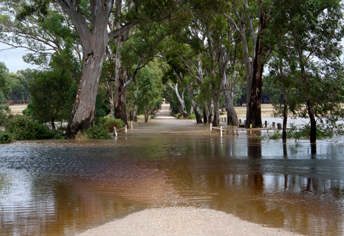
Muckleford Creek over Lewis Rd, September 2010. The floods have been a boon ecologically, but although Victoria had eight major floods last century, Councils do not have adequate maps of flood levels. So building continues on flood plains. Photo: Bronwyn Silver

On the first issue, Damian noted that town levies are the responsibility of councils, but that rural levies protecting property are a long standing maintenance problem and the source of continual disputes as to who is responsible for them. The lower Loddon has 200 kilometres of levies, and these failed in 117 places in January. It has been estimated that restoration of levies could cost $650 million. He praised the government’s offer to buy out farmers in vulnerable areas, as a more practical long term solution to inevitable floods than prohibitively expensive protection measures.

On the second theme, Damian noted that the CMA had been ‘howled down’ in Creswick for its supposed responsibility for floods there, but subsequent investigations had completely vindicated its position. Bridges and road culverts are major causes of water blockages and subsequent level rises, but the major problem is building on flood plains. The CMA is continually challenged by developers in VCAT when it opposes building in such areas.

He agreed that peak flood level models should be incorporated into planning schemes on a state wide basis, to avoid the situation of people building on flood prone land. Incredibly, he noted that current modelling of flood risk zones is inadequate. [In spite of the fact that Victoria had serious floods every 10-20 years in the last century— in 1909,1916,1917 1974 1956 1974, 1990, and 1993— it seems we still don’t have good maps telling us where not to build!]

Continue reading

Posted in News | Comments Off on Floods: keeping ‘out of harm’s way’

Reports come flooding in

Coincidentally, the Comrie Report on the 2010-11 floods has just been released. Although the report concentrates on the performance of emergency services, it does contain some enlightening remarks which underline Damian Wells’s  argument. For example:

‘It is important to understand that the application of appropriate land use planning controls as part of municipal planning schemes is considered to be an effective means of minimising flood damage. Municipal councils are required to take into account flood risk when considering appropriate development on floodplains.’ [page 6]

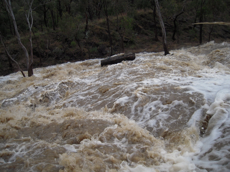
Expedition Pass spillway, January 2010. The sheer volume of water guarantees that flood plains will flood. Repeated enquiries have urged tighter building controls on floodplains, to minimise asset damage. Photo: Bernard Slattery

The Comrie report makes reference to a document with which we were not familiar: the 1998 Victoria Flood Management Strategy. This document, currently under revision, is available here

Among other things, the Strategy says

‘Appropriate land use strategies are the most effective means of reducing the growth in flood risk and damages. With the introduction of Victoria Planning Provisions [VPPS], the ability of Victorian councils to carry out their land use planning role will be strengthened. The VPPs provide uniform statewide policy and control for development and works on floodplains. They require that flood risk must be considered in the preparation of planning schemes and in making land use planning decisions, and that land affected by flooding must be shown on planning scheme maps.’ [Page 9]

It seems from the substance of Damian Wells’s talk to the AGM that this has not happened.

The Parliamentary Environment and Natural Resources committee is due to present a report on the floods later in the year.


Posted in News | Comments Off on Reports come flooding in

FOBIF Elections 2011

At the AGM on Monday July 11, Public Officer Chris Morris announced that the following nominations had been received before the meeting:

President: Marie Jones

Vice President: Nev Cooper

Secretary: Bernard Slattery

Treasurer: Bronwyn Silver

Committee Members: Frank Panter, Kylie McIndoe

As the number of nominated candidates equalled the number of positions on the committee, according to the Constitution, the above were declared elected.


Posted in News | Comments Off on FOBIF Elections 2011

What’s happening up at Morgan’s Track?

The rather sad sign below is a marker on Morgan’s Track Chewton of the Ecological Thinnings Trial conducted by Parks Victoria beginning in 2003.

Despondent sign at Morgan's Track, July 2011: we hope that ongoing research on this trial will prove valuable. We have been assured that the research continues. Photo by Bronwyn Silver

The trial was proposed by the Environment Conservation Council when it recommended the establishment of new Box Ironbark reserves in 2001. The intention is to experimentally aim at the restoration of a pre white settlement forest structure by strategically thinning selected plots in the aim of getting a woodland of more widely spaced, larger trees, and a healthier, more diverse understory. In fact, our woodlands are on the whole gradually thinning themselves as weaker trees die: so the trial is an effort to speed up the work of Nature.

FOBIF did not oppose the trials, even though we thought that in our region they were misconceived, and the money and resources could have been better spent elsewhere—on weed control, for example. We did concede, however, that the accompanying monitoring and research could prove very valuable for our understanding of these ecosystems. For a more detailed account of our views, you can read an item from our 2008 newsletter here.

FOBIF members did a prowl around the Morgan’s site on July 8. This area has always been rich in wildflowers, and it looks like the coming spring will not disappoint. Even in the dead of winter there’s plenty to see, as the pictures show.

Even in the dead of winter, there's plenty to see at Morgan's Track. Photos by Bronwyn Silver, July 2011

And the effect of the trial? Monitoring up to 2008 cautiously suggested that the thinning had up to that point been positive in encouraging understorey diversity.

Continue reading

Posted in News | Comments Off on What’s happening up at Morgan’s Track?

Mount Alexander environment officer: an update

We have received a response from the Mount Alexander Shire to our budget submission on the appointment of a ‘Natural resource officer’ [see post June 3  ]. We had expressed concern that the position was a six month only appointment. Council informs us that ‘it is intended that the position will be for at least twelve months and will be reviewed annually during the budget process. There is only provision for six months salary in the Budget for 2011/12 as the position is expected to commence in January 2012.’

Posted in News | Comments Off on Mount Alexander environment officer: an update

Lichens galore

One feature of the relatively good rains we’ve had in the last year or so has been the great shows of lichens.

Lichens are partnerships between a fungus and an alga. The algal partner enables the organism to use photosynthesis to produce carbohydrate, something a fungus can’t do by itself. They are maybe the most widespread life form on the planet, flourishing from the polar regions to the tropics. Being sensitive to pollution, however, they’re not so common in cities.

There are over 20,000 species of lichens world wide, and 3,000 in Australia. Sometimes they just seem to be a colour on a rock, as in this orange Caloplaca sp:

Caloplaca sp, Poverty Gully water race, near Castlemaine: crustose lichens can seem to be simple discolorations on rock. Photo: Bernard Slattery

Caloplaca is a crustose lichen: you  can’t see its undersurface because it’s completely encrusted onto its substrate. But maybe the commonest and most widespread Australian genus of lichen is the Xanthoparmelia, a foliose lichen: that is, it grows more or less flat to the ground in sheets, but not entirely attached [though sometimes it seems pretty tightly stuck to the ground]. Australia has 300 species of this genus, of which over 200 are endemic.

We’ve all seen one or other species of Xanthoparmelia. At the moment, they’re all over our bushland.

Here’s one, from the Newstead Cemetery:

Xanthoparmelia, Newstead cemetery: the grey green, yellow green or grey brown colours of this species can be seen on rocks, roof tiles and even roadways all over the shire.

And here’s another, on a bottle in Chewton:

Lichens can grow nearly anywhere, but they are sensitive to air pollution. Photo by Bronwyn Silver, 15 October 2010.

Of course, things are never as simple as they might be. If you see a greenish, foliose lichen growing on live or dead trees [and, at the moment, it’s hard not to see them–they’re all over the place] it is most likely to be the genus Flavoparmelia. Xanthoparmelia grows mostly on rock or rock like surfaces.

Continue reading

Posted in Nature Observations, News | Comments Off on Lichens galore

Is is a bird? No, it’s a plane

Views can be a wonderful experience, but a double edged one: a house may offer a magnificent view of a nearby hill, but a person sitting on that hill may not be pleased by having to look at the house in question.

Aeroplanes offer magnificent views: but people on the ground who have to put up with their intrusiveness and noise possibly won’t be impressed that the passengers in the sky are getting ‘the experience of a lifetime’, as one helicopter company describes its scenic flights over the Port Campbell National Park.

The Strathbogie Shire is facing a different version of this problem, in relation to the largest tract of Box Ironbark bushland in Victoria. Skydive Nagambie, which claims to be ‘Australia’s premier skydiving company’, is proposing to set up an airfield 3 km from the Heathcote-Graytown National Park, in the vicinity of Mount Black.

It’s hard to believe that planes would be dropping parachutists over the park, to fall into trees: but the prospect of up to 20 flights a day on up to 215 days in the year even close to the park is not impressing some local naturalists. Objections to the application have been made by the Trust for Nature and local environmentalists. For more info, the Strathbogie Shire website is at www.strathbogie.vic.gov.au, and local objectors can be contacted via rachelots@hotmail.com

Posted in News | Comments Off on Is is a bird? No, it’s a plane

Fire history: filling in the facts

The Victorian National Parks Association has released a graph showing the control burn and bushfire history of Victoria in the last 75 years. The graph is based on Forest Commission and Parliamentary records, and can be seen with explanatory comments by Phil Ingamells on the VNPA Website

Among other things, Phil Ingamells points out that there have been ‘only four occasions since 1934 (when management burn records started) when the reported figure exceeded 300,000 hectares in a year…The future statewide target of 390,000 ha is setting us on a level of management burning unprecedented in Victoria’s history.’

On the Stretton Royal Commission into the 1939 fires, he comments:

‘The Royal Commission into the 1939 fires, so eloquently penned by Judge Stretton, nevertheless sent mixed messages for controlled burns. In the introductory pages, he had no sympathy for ‘settler’ burns.

“They burned the forest floor to promote the growth of grass and to clear it of scrub… The fire stimulated grass growth; but it encouraged scrub growth far more… The scrub grew and flourished, fire was used to clear it, the scrub grew faster and thicker, bushfires, caused by the careless or designing hand of man, ravaged the forests… And so today in places where our forefathers rode, driving their herds and flocks before them, the wombat and the wallaby are hard put to find passage through the bush.”

‘Yet Stretton asked for a greatly increased rate of fuel reduction burning by the Forests Commission which, in the period before the 1939 fire, was burning an average of just 7,500 hectares per year.’

The VNPA is urging a more strategic approach to management burning, in preference to the crude policy of burning a set number of hectares per year. This reflects the thinking of environment groups generally–for example, FOBIF and he North Central Victorian Combined Environment Groups [see Richard Goonan’s report on the Bendigo Round Table below].

Posted in Fire Management | Comments Off on Fire history: filling in the facts

Touch base with the changing world

The blogroll on the right of this page is an indicator of the intense local interest in happenings in the natural world. We would be the first to admit that you can spend too much time in front of a screen, but strongly recommend regular visits to these sites.

The following are recent highlights of local nature blogs:

The Castlemaine Field Naturalists have a detailed list of local species, organised in clear groupings, and with excellent photos attached: it’s a great way of checking plant ID.

The highlight of the Connecting Country website this year has been the Nest Box project report, with terrific ‘at home’ phascogale and sugar glider photos.

The Natural Newstead site is the nearest our region has to a detailed online nature diary, and is packed with interesting info on bird life and seasonal change. It has had a detailed and fascinating coverage of the new life in the Moloort swamps this year, including pics of local brolgas.

The Muckleford Landcare website has a very good collection of photos of FOBIF’s excursion into the ‘legendary’ Muckleford Gorge, as well as reports on revegetation along the Maldon railway line.

One of the smallest reserves in our region is the Walmer South Conservation Reserve—but it has its own website tracking subtle seasonal changes in the reserve via excellent pics. Recent posts include photos of moss growth on old shoes!


Posted in Nature Observations | Comments Off on Touch base with the changing world