Fire 1: ‘This time, it will be different…?’

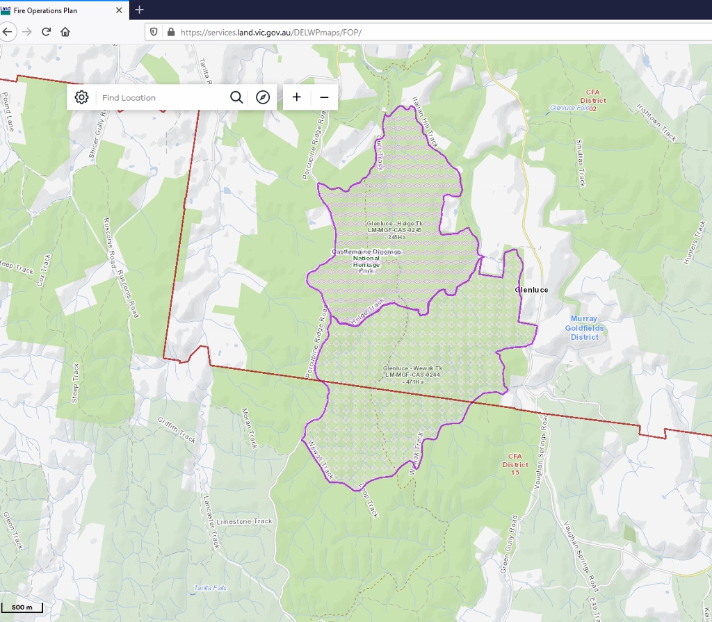
FOBIF has received an answer from DELWP fire management to our questions about proposed burns in the Diggings Park in the areas of Helge and Wewak tracks.

Readers will remember we asked what lessons the Department had learned from its past efforts in this area, and how the future exercises would be handled differently. Here’s the answer:

‘I am confident in saying that we have learnt a lot from continually reviewing our practices and reflecting on what went well and what didn’t. You have identified 2 burns where aspects of the delivery was not as desired. There are learnings from every burn that are considered and adopted accordingly.

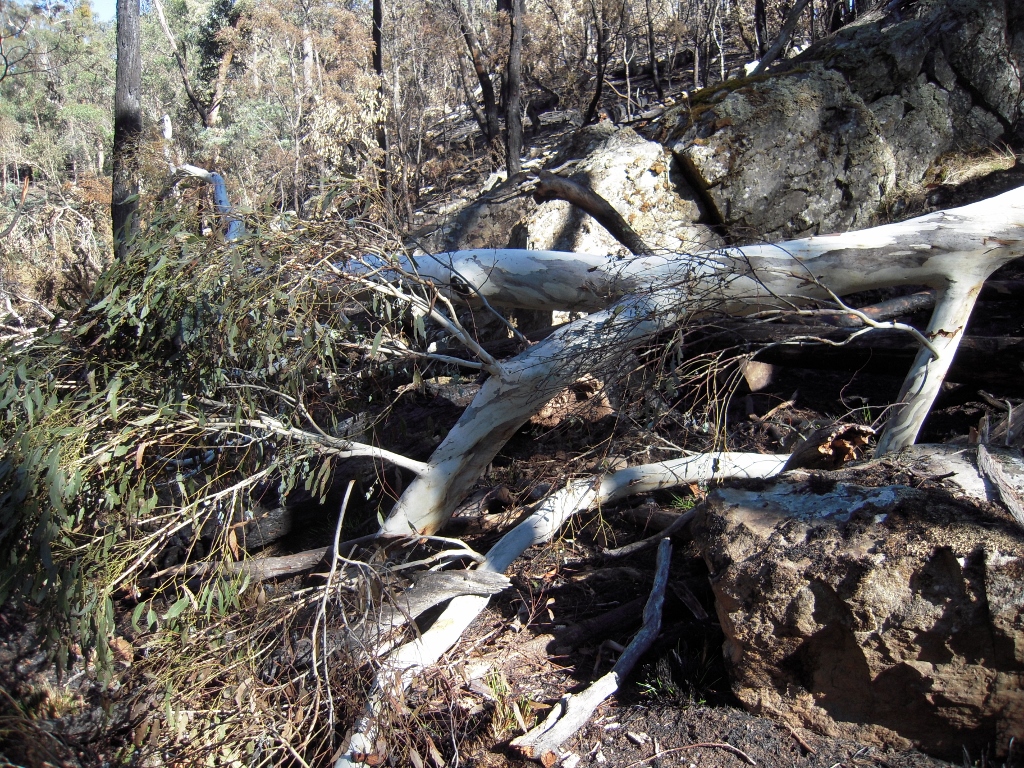
Large Candlebark brought down by indiscriminate DELWP’ ecological burn’, Tarilta valley 2012. FOBIF is concerned that the proposed burns could bring a similar result.


‘Along with engagement, rehabilitation is now a significant consideration in the planning of the burn. The Murray Goldfields now requires the Planned Burn Operations Officer (the officer in charge on the fireground on the day) to complete for every burn a;

  • ‘Post Burn Rehabilitation Check list (evening of burn day or the next day). This information is used to develop works plans for crews to carry out the required rehabilitation addressing issues such as signage, track rehabilitation and catchment protection measures.
  • ‘Post Burn Severity and Coverage document, capturing the coverage of the fire within the unit and its intensity.

‘We seriously review and consider our ignition options and plans. This is very much influenced by the fuels, the desired outcome and our crew safety. Seasonality is also consideration. Conditions as they present at the moment, find gullies still green after summer rains and therefore presents as a good opportunity to treat a burn without impacting significantly on gully lines. We have also observed that lower intensity burns seem to not generate as much fuel and accumulate fuels slower than burns that are generally burnt hotter. In addition, lower intensity burns generally maintain the Overall Fuel Hazard (OFH) levels under triggers for more years than higher intensity burns.

‘Backing this up is that Bureau of Meteorology (BOM) forecasting has improved which allows us to identify burn windows including follow weather and rain events with more certainty. During burning periods, the state establishes ongoing liaison with the BOM for weather forecasting including daily weather teleconferences and one on one liaison with Meteorologist.

‘I would like to reiterate that our staff both within the office and in the field are encouraged to reflect on their practice and provide feedback. This then informs our thinking and in some cases requires adjustments to our methodology. We pride ourselves in being dynamic and adaptive. I think you would agree that our approach to burning now is considerably different to how it was in the past.’

This letter is too vague to satisfy provide a convincing answer to our questions. In particular we don’t get an answer to this question:

‘What were the conclusions of post fire monitoring after the above two exercises [both as to ecological effects and fuel reduction]?’

Nevertheless, FOBIF is partly reassured by the implied admission here that hot burns actually generate fuel, rather than reducing it. We hope that this means a commitment to more care in the management of these fires.

It is true that managers are more aware of the complexity of their task than they used to be: but are the barbaric days of the past over, when burn methods seemed to be ‘throw in a match and watch it go’? We’re not so sure. For one thing, it never seems to be possible to see the documents referred to above: especially, we’d be interested in seeing the ‘post burn rehabilitation check lists’.

Posted in News | 3 Comments

Fire 2: Let’s see what is at stake

The two zones proposed for burning are between the Italian Hill track and the Wewak track, south of Vaughan Springs (see the map in our post). The northern section of this area was burned by the Department in the early 2000s. The burn was hot in patches: not only did it bring down a lot of trees, but it provoked substantial dense regeneration of eucalypts, rather counteracting the fuel reduction effect. The fallen trees did, however, block some wildcat trailbike tracks, thus reducing one scourge for a few years.

In Stone’s Gully, part of the proposed burn zones.

The two zones are strongly marked by past mining activity, and are crossed by the Goldfields Track. In spite of this, for many years they have been among the least disturbed parts of the Diggings Park. Fungi, lichens and moss beds are abundant. The gullies and creeks feature impressive Candlebarks. As FOBIF walkers found a couple of years ago, the ridges also feature unusually large trees. One of FOBIF’s concerns relates to this: that Department burns very often (unintentionally) bring down such trees.

Rock wall, Stone’s Gully. The area is abundant in moss, lichens and fungi.

One very major concern, however is this: the two zones seem to be too large to allow for any detailed management attention to be paid to ecological concerns.

FOBIF will continue to pursue this theme with fire officers.

Posted in News | 1 Comment

New twist for this year’s Camp Out on the Mount

Since 2013, Connecting Country, local Landcare, and other community groups have organised a free ‘Camp Out on the Mount’ event on Leanganook/Mount Alexander. This year, to reduce the risk of having to cancel or reschedule, they have decided to jump the gun, get creative and plan for a virtual ‘Camp Out on the Mount’.

When: 3 – 18 April 2021
Where: 
Online at www.connectingcountry.org.au/landcare/camp-out-on-the-mount-2021/

Asha Bannon, Mount Alexander Region Landcare Facilitator, says, “We hope to capture the ‘Camp Out on the Mount’ spirit by encouraging everyone to engage with our special ‘Camp Out 2021’ web pages, and inviting you to contribute to our ‘Camp Out Collage’.”

Each web page focuses on one of the elements that make the Camp Out special: ‘Camping out’ (of course!), ‘Caring for the land’, ‘Loving Leanganook’, and ‘Connecting with Indigenous culture’.

For each contribution you make to the ‘Camp Out Collage’ you will be entered into the draw to win one of several special prizes (maximum four entries per person), including a nest box, tubestock plants, and a native plants book bundle. Please note that you are only eligible to win the prizes if you live in Australia, and some of the prizes (such as the nest box and plants) will only be available for properties in the Mount Alexander region (central Victoria).

Anyone and everyone is welcome to participate, so hop online and join the fun! If you have any questions, please contact asha@connectingcountry.org.au

This event was made possible by the Victorian Landcare Facilitator Program, funded by the Victorian Department of Environment, Land, Water, and Planning.

Posted in News | Comments Off on New twist for this year’s Camp Out on the Mount

Making the stones talk

FOBIF’s March ‘walk’ yesterday was a geology tour of the district led by Clive Willman. Good numbers turned up despite the rain, which turned out to be reasonably friendly, though umbrellas did come out at one of the stops.

Clive William addressing the tour group at the first stop.

Volcanoes, raging rivers, and wet beech forests were all part of the picture Clive drew out of the stones to portray a set of pictures of this region over millions of years. We hope readers will understand that the plot is a bit hard to summarise in a few words: a fuller account will appear on this site in a few weeks.

Much thanks to Clive for his detailed preparation and compelling presentation: for the participants, those stones will never look the same again.

Posted in News, Walks | 1 Comment

The questions are…

As a follow up to Rob Simons’ recent correspondence with Forest Fire Management about two proposed burns in the Diggings Park (see the comment at the end of our last week’s post), FOBIF has written to DELWP’s Acting Regional Fire Manager, asking for a few details about the burns, which are slated for 2022 and 2023.

The two proposed burns are east of the Porcupine Ridge road, in the south end of the Diggings Park.. FOBIF is critical of two previous burns in this area, and is hopeful the Department can improve its performance this time around.

The letter reads:

A few questions arising from your recent exchange with Rob Simons about the two planned burns CAS 0244   and CAS 0245.

These two blocks are of course close to or contiguous with two previous Department burns, Tarilta valley and Loop Track, burned eight and ten years ago. You may remember we had an exchange of letters on the matter at the time.

On these burns there are in our opinion two undeniable facts:

  1. The Tarilta burn was followed by rain which washed a very large amount of soil off the valley sides and into the creek. We couldn’t quantify the soil loss, but the mud in the creek was up to the waist a week after the fire, and the Limestone Track causeway was blocked.
  2. The Loop track fire killed a significant number of big trees, and has resulted in rampant and dense regrowth of wattles and eucalypts. It’s now one of the few areas in the region where it’s almost impossible to walk any significant distance without a struggle. The vegetation load in this block is heavier than in adjoining unburned areas.

In both cases the outcomes were the result of fires that were arguably too hot; and in the case of the Tarilta fire, the serious soil loss was a direct result of stripping vegetation from steep valley sides a few days before forecast heavy rain.

I have an extensive collection of photos taken soon after the burns.

My questions are:

  1. What were the conclusions of post fire monitoring after the above two exercises [both as to ecological effects and fuel reduction]?
  2. What lessons have been drawn from the monitoring?
  3. How will the management of the upcoming burns be different [if they will]? I note, for example, that the two blocks contain significant areas of creekline vegetation and damp forest]

Sincerely,

Bernard Slattery

FOBIF Secretary

*****************

We’ll let readers know when we get an answer.


Posted in Fire Management | 2 Comments

FOBIF geology tour

The FOBIF geology tour will still take place today despite the rain. For people who have registered we are meeting at 9,30 at the Community House. 

Posted in News | Comments Off on FOBIF geology tour

So: what’s new?

Is public land management governed by science? Or is it by a chaotic mix of politics, self interest and old habits?

Let’s not by cynical about this, and see what researchers on public land are finding out. This week the Victorian Environment Assessment Council is running a series of five-minute talks, by twenty postgraduate students, public land managers and scientists who conduct research on public land. The talks will take place from 10 am to 12.30 pm next Tuesday March 23.

This symposium is part of VEAC’s program of online events throughout 2021 that celebrate the 50th anniversary of VEAC and its predecessors. To register go to https://www.eventbrite.com.au/e/science-into-management-research-on-victorias-public-land-registration-140720664295

This event is being co-sponsored by the Arthur Rylah Institute for Environmental Research, Museums Victoria, the Royal Society of Victoria, and the Commissioner for Environmental Sustainability, Victoria.

Posted in News | Comments Off on So: what’s new?

Fire: is there a change in the air?

The announcement of a new year of fuel reduction activity by DELWP provokes the usual thoughts: will the program be effective in actually reducing fuel? Will it be properly monitored? Will there be negative effects environmentally and economically (over-hot burns, smoke damage to wine grapes, etc)?

In that context, it’s worth drawing attention to the growing interest in indigenous cultural burning, and in particular to the Victorian traditional owner cultural fire strategy, produced by the traditional owner cultural fire knowledge group. You can find this 28 page document online here.

The six principles outlined in the document are as follows: 

  1. Cultural Burning is Right Fire, Right Time, Right Way and for the right (cultural) reasons according to Lore. There are different kinds of cultural fire practices guided by Lore applicable across Victoria’s Countries.
  2. Burning is a cultural responsibility. Traditional Owners lead the development and application of fire practice on Country; the responsibilities and authority of Traditional Owners are recognised and respected.
  3. Cultural fire is living knowledge. Aboriginal fire knowledge is shared for continual learning and adaptive management. Traditional Owners will work together on each other’s Country to heal Country and guide practice development. Knowledge and practice are shared.
  4. Monitoring, evaluation and research support cultural objectives and enable adaptive learning. MER will be used to build a body of evidence that allows cultural burning to occur and grow.
  5. Country is managed holistically. Traditional Owners manage Country holistically to address multiple values and objectives, healing both Country and culture. Partnership arrangements and management objectives are tailored to each regional and cultural landscape context. This includes analysis of the tenure, regulatory and operational arrangements to support cultural fire application, other beneficial Indigenous management practices, together with a process of learning to continuously improve planning, management and action.
  6. Cultural Fire is healing. There are substantial positive impacts to Traditional Owner wellbeing and confidence through providing access and authority to practice on Country.

The whole of this document is worth an attentive reading. The authors acknowledge that the strategy has limitations: ‘Traditional Owners have limited authority, resources and capacity to develop and apply cultural fire practices on Country according to the principles described in the strategy.’ Therein lies a particularly interesting challenge.

Posted in News | 1 Comment

Native pea greeting cards and guide now available

We have taken some of photos from the new Native Pea book and made them into greeting cards with detailed species notes on the back. They are now available in a set of 8 with envelopes for $20.

The cards and our field guide, Native Peas of the Mount Alexander Region, are now available at Stoneman’s Bookroom, the Tourist Information Centre, the EnviroShop in Newstead and the Book Wolf in Maldon  Or see the links on the right hand side of this page to purchase directly from FOBIF.

Posted in News | Comments Off on Native pea greeting cards and guide now available

Ooops!

In what might be a world record short time between announcement and cancellation, FOBIF has been forced to call off its Zoom launch of Native Peas of the Mount Alexander Region.

The timed launch clashed with an important Connecting Country event on farm dams, and we were reluctant to interfere with this program.

Further, COVID 19 restrictions on attendance, the upcoming Castlemaine State Festival, and Easter, have all conspired to drastically limit the number of possible windows of opportunities for a launch…so we’ve decided to abandon the idea altogether. Our apologies for any inconvenience to members.

However, you can still buy the book: it’s available at the usual outlets from tomorrow [Thursday 10 March]. And Ian Higgins will be giving his talk on native peas at the FOBIF AGM later in the year, when, hopefully, we’ll be able to gather in reasonable numbers in the same place!

Posted in News | Comments Off on Ooops!