Bright winter sunshine, obscure corners

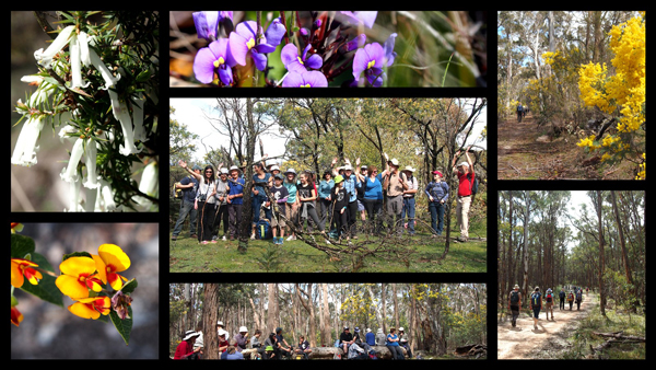
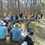
A bitterly cold morning didn’t deter FOBIF walkers from tackling some obscure corners of the Columbine and Salters Creeks valleys on Sunday. The corners turned out to be even more obscure than intended when a navigation error by walk leader Bernard Slattery landed the group in an unexpected approach to Salters Creek. Well, as the great Paddy Pallin might have said, in this country you’re ‘never quite lost’, and we all emerged triumphant and on time.

The walk included a look at one of Doug Ralph’s favourite haunts: Charlie Sanger’s hut, near Columbine Creek. As usual, we provided perfect winter weather for the occasion.

Lunch at Salter's Creek

Lunch at Salters Creek

Walkers at the Sanger hug. Photo by Noel YOung

Walkers at Sanger’s hut site. Photo by Noel Young

Bernard addressing the group at Sanger's hut site.

Bernard addressing the group at Sanger’s hut site.

Posted in News | Comments Off on Bright winter sunshine, obscure corners

The scalping of Fryers Ridge [1]

Visitors to the Fryers Ridge this past week have been stunned to find that major works on the verges of the Ridge Road have scoured the earth bare, virtually eradicating a large part of one of the region’s most significant wildflower areas.

The road runs along the top of the ridge, dividing the Fryers Flora reserve from the State Forest.

The works have been designed to eliminate blind bends, and facilitate access in the event of fire: according to DELWP: ‘the works were completed by the Department tractor …to clear the road verges of vegetation as a recent roads inspection showed that the verges were overgrown and had a traffic near miss a while ago.’

Fryers Ridge Road, near the Irishtown Track: in places the road is twice as wide as the Midland Highway

Fryers Ridge Road, near the Irishtown Track, July 6: in places the road is wider than the Midland Highway

The roadside verge has been ‘scalped’ along many hundreds of metres, and in addition earth has been scraped and piled up as much as 10 metres into the bush.

These works are a perfect example of a problem FOBIF has had with DELWP managers for many years.

In discussion with Department and Parks officers on the road on Friday July 10th we were amazed to discover that they did not attach any particular importance to these roadside verges,   because no rare or endangered species had been drawn to their attention there. It seems the area is in a ‘general zone’, which seems to translate as ‘nothing much to see here.’

On Fryers Ridge: for long sections vegetation off the edges of the roadway has been obliterated over hundreds of metres

On Fryers Ridge: for long sections vegetation off the edges of the roadway has been obliterated over hundreds of metres


This is the problem with most road works: for example, a 2012 DSE Document on roadside vegetation management for bushfire risk mitigation states that ‘Bushfire risk mitigation works that are likely to have a significant environmental impact on the road reserve will require a planning permit.’ If the area in question is not seen by managers as special, and is not on their data bases as containing rare species, it seems that road workers aren’t instructed to be particularly careful to look after the area: works are not seen to have a ‘significant environmental impact.’

It seems to us that there’s an underlying assumption in the Department that whatever mess is made in the short term will fix itself in the longer term, because the bush recovers. We were told this in our discussions with managers on Friday: this kind of gouging had been done before, and the bush had come back OK…it may even be improved by this kind of disturbance…so it’s not so bad, is it? Our opinion is that whatever values such areas as this have are there in spite of such works, and every time they are done, especially, say, in drought times, the recovery is less. Here’s a question: Has the Department made any long term assessment of the effects of these kind of works?

Posted in Fire Management, News | 1 Comment

Maybe THIS is the saddest sign in the region?

The sign depicted in our July 5 post may have been trumped by this one, on the Fryers Ridge: ‘DO NOT…remove soil or rock.’ This injunction doesn’t apply to road works.

Sign on Fryers Ridge: it doesn't sit well next to the gouging of the nearby Ridge Road. FOBIF has argued that road works should be planned with careful concentration given to adjacent bushland.

Sign on Fryers Ridge: it doesn’t sit well next to the gouging of the nearby Ridge Road. FOBIF has argued that road works should be planned with careful concentration given to adjacent bushland. The track depicted is not the recently scoured ridge road.


Posted in Fire Management, News | Comments Off on Maybe THIS is the saddest sign in the region?

Is this the saddest sign in our region?

Well, we think it could be a credible nomination, anyway: an eloquent testament to past abuse of the land, painfully slow recovery, and perhaps the under resourcing of our land management bodies.

Near Perkins reef in the Maldon Historic Reserve. The sign speaks volumes about the under resourcing of public land management in Victoria.

Near Perkins Reef in the Maldon Historic Reserve: the sign speaks volumes about environmental history, and the painfully slow rate of recovery from land degradation.


Posted in Nature Observations | 1 Comment

Fire’s off…and on

Several more substantial proposed burns have been removed from the current DELWP Fire Operations Plan. Apart from the Amanda’s Track proposal, which we have previously reported, these include:

Donkey Farm Track [in the Maldon Historic Reserve], Chewton Railway Dam [in the Fryers Forest], Pepper Tree Track [in the Tarilta catchment], and  Zig Zag track [in the Sandon State forest].

Sandon State Forest: the 491 ha management fire in this zone has been deleted from the fire operations plan.

Sandon State Forest: the 491 ha management fire in this zone has been deleted from the fire operations plan. This forest was ‘almost completely denuded of useful timber’ by 1870.


All of these were substantial burns for our area, and we had expressed reservations about them for one reason or another in our submissions to the Fire Operations Plan.

Withdrawal of these burns has been  ‘based on a review of the risk, feedback from community groups and an operational assessment’, according to Andrew Koren, DELWP’s local program manager for planned burning, in a detailed response to FOBIF’s submission to the FOP, received last week.

The Department will proceed with its plans to burn Mount Tarrengower, though how this will be done is still under consideration. The southern slope of the Mountain, around Perkins Reef, was recently burned. Additionally, a new burn is proposed for Fryers Ridge, around the Old Tower Track. Crude track upgrades in this area were done over the last couple of years.

Posted in Fire Management | Comments Off on Fire’s off…and on