CFNC Meeting: Native Grasses and the Moolort Plains

On the evening of 13 July there will be a special Castlemaine Field Naturalist Club meeting where Ern Perkins Central Victoria Grasses Identification Guide CD will be launched and Geoff Park will give a presentation on the Moolort Plains. To find out the full details see the Connecting Country website.

Posted in Nature Observations | Comments Off on CFNC Meeting: Native Grasses and the Moolort Plains

Get the birds at the AGM

Here’s advance notice that FOBIF’s Annual General Meeting will take place at Castlemaine Continuing Education Centre at 7.30 pm on Monday August 13.

After the usual business, there will be a short talk by Damian Kelly on the challenges and rewards of bird photography. Readers of this site will be familiar with Damian’s brilliant photos of local bird life, and he will illustrate his talk with some recent examples.

Brown Thornbill. Photo by Damian Kelly. This is one of three photos of birds by Damian included in the current FOBIF exhibition at Togs Cafe.


Posted in News | Comments Off on Get the birds at the AGM

Walkers in a Blackened Landscape

The June FOBIF walk led by Doug Ralph was to the remote Tarilta Creek Valley. Readers of this site will know that this area was the subject of controlled burn this Autumn. (See previous FOBIF post.) The day allowed walkers to see the effects of this burn first-hand.

Most of the walk was through bush that had been devastated. Mature trees were lying burnt on the ground and severe erosion was evident as a result of  the burning of steep slopes. Consequently parts of this once beautiful creek were now full of black silt. Apart from epicormic growth on burnt trees and some ground covers such as Scented Sundews there was little evidence of recovery. One of the walkers, Noel Young, commented:

I was dismayed by the number of large mature eucalypts that were completely destroyed in the bottom of the valley.  This represents the destruction of much needed wildlife habitat which has taken maybe 50 to 100 years to grow.  I doubt if this was intended, but it probably reflects the methods used, ie, weapons of mass destruction (fire bombing) with little or no ground supervision.  Hardly a “controlled burn”.

Below are two slideshows. The first one contains photos of Tarilta Gorge before the controlled burn. The second collection contains photos taken after the burn including on the walk.


At the end of the walk there was a short discussion led by Doug about the area and the effects of the burn. Mount Alexander Shire Councillor, Christine Henderson, spoke about the Municipal Fire Plan which has just been released and encouraged walkers to submit comments to Council about the burn in this area based on their observations. See recent FOBIF posts here and here for more detail on this.

The July FOBIF walk on 15 July will be to the McKinnon property at Yandoit. Malcolm Fyffe will be the leader.


Posted in News | Comments Off on Walkers in a Blackened Landscape

Plant some understorey, check out a weed

FOBIF is planning an understorey planting and weed attack working bee at the famous Chewton Yellow Box on National Tree day, Sunday July 29, from 10 am to 12 noon.

FOBIF foundation president Doug Ralph at the Chewton Yellow Box--it's definitely a monument worth looking after. Photo: Bronwyn Silver


The tree, one of the oldest in the district, is on the Great Dividing Trail near Fairbairn Street. FOBIF last year did some bridal creeper eradication work at the site, and this is a follow up effort. The site is about 100 metres from Forest Creek, near a small school pine plantation. The quantity and variety of weeds in this area is quite desperate, but the potential for restoration of a beautiful creek valley landscape offers plenty of motivation for workers to put a dent in the evil empire.

There’ll be more details closer to the event–but put it in your diary now!


Posted in News | Comments Off on Plant some understorey, check out a weed

Municipal Fire Plan [2]: a preliminary look

The draft Mount Alexander Municipal Fire Management Plan is now out for consultation, as we reported below.

The draft contains some interesting information and some puzzling features. Among the former:

  • The authors note that a community survey before the draft was compiled targeted residents under 25, but no responses were received from this group.
  • In responses to the community survey ‘Protecting life and improving knowledge were considered to be the most important with regard to fire management, with minimising damage to the environment rating slightly higher than minimising fuel loads.’ This could be a balanced community view, or maybe a sign of a divided community—the draft doesn’t make this clear
  • Historically there have been 53 fires per year on average in this region: of these, only 6, on average, have been ‘natural’ [ie, resulting from lightning strikes]. The rest have been caused by carelessness, technical malfunctions or arson.
  • ‘State Government research has found that 75% of people living in the most fire prone areas do not believe that they need a fire plan.’

Among the puzzling features of the plan are the following:

  • The plan lists four ‘key bushfire landscapes’ on page 16: grass, crop and stubble; box and ironbark forest and woodland; tall [sclerophyll] forest; and urban. Not included is ‘Pine plantation.’ This is evidently because the CFA does not consider these plantations to be as serious fire risks as the others. We believe, however, that the draft may be altered to include the plantations as a possible bushfire landscape.

Gorse which somehow escaped a DSE control burn near Quarz Hill, December 2011: The Municipal Fire plan draft recommends that fuel reduction programs be integrated with weed control.


  • On page 22 we read that ‘Mount Alexander is home to vast tracts of bush wilderness with many communities and critical infrastructure situated in remote or difficult to access situations.’ This is a peculiar statement, given that there is no ‘wilderness’ in this region. Perhaps it will be corrected or modified in the final version.

There are many good features in the draft. One of them is the recommendation that fuel load reduction programs should be integrated with weed management, ‘particularly in relation to gorse, broom and blackberry weeds.’ [Readers of this site will remember that we have been irritated by DSE’s failure to pick up on this very reasonable idea]. Other features will need careful community scrutiny.

FOBIF will be making a submission on this draft in due course. It’s an important opportunity to engage in a constructive discussion on the task of minimising bushfire risk while respecting what makes our bushlands valuable and important. The document can be found here. Feedback can either be given at the info sessions detailed in our post below, or via the not terribly friendly Council feedback form, which you can find here . Forms should be marked ‘for the attention of the Emergency Management coordinator.’


.

Posted in News | Comments Off on Municipal Fire Plan [2]: a preliminary look

Mount Alexander municipal fire plan

The Mount Alexander Shire Council, together with the CFA, DSE and other agencies and groups [not including FOBIF], has developed a community fire plan for the next three years.

The plan is on display in the Castlemaine Market Building from Monday to Wednesday till June 27. It can also be seen online at www.mountalexander.vic.gov.au

For the information of the public there are open house sessions on the plan at the Market Info centre on Wednesday 13 June from 11.30 am to 1.30 pm, and on Monday 25 June from 4.00 pm to 6.00 pm; these sessions will also be held at the Maldon visitor info centre on Friday 15 June from 4.00 pm to 6.00 pm, and at Harcourt ANA hall on Friday 22 June from 5.00 pm to 7.00 pm.

There will also be a one-hour feedback workshop at 6 pm on Wednesday 27 June at the Ray Bradfield room, Castlemaine.

Posted in News | Comments Off on Mount Alexander municipal fire plan

Tall Greenhoods are flowering

Tall Greenhood, Poverty Gully. Photo: Bronwyn Silver, 10 June 2012

The Tall Greenhood Pterostylis longifolia is one of 16 local species of Greenhoods. Worldwide there are 120 species with about 100 of these endemic to Australia.

Along with other Greenhoods, this one lures insects, usually gnats, to the plant with pheromones. When the insect touches the lower lip of the orchid (labellum) it flings the insect back into the hood and closes over it. The movement of the insect as it attempts to escape assists in the pollination process. Once the insect escapes the ‘trap’ is reset.

Tall Greenhoods are one of the earliest species of Greenhoods to flower in this area. They are characterised by long leaves and multiple flowers on each stem. As with other Greenhoods the flowers are translucent which is thought to encourage trapped insects to move towards the light.

To view several other types of Greenhoods have a look at our FOBIF Flickr Gallery.

Posted in News | Comments Off on Tall Greenhoods are flowering

FOBIF photo show at Tog’s Cafe

The latest FOBIF Mamunya exhibition opened at Tog’s Cafe in Lyttleton Street, Castlemaine last Friday. It runs till the 13 July. The exhibition continues a tradition the Friends started in 1999 with their first Mamunya festival. This word comes from a Dja Dja Wurrung chant, ‘pata, mamunya, jirarunga,’ meaning, ‘wait a while, don’t touch it, growing up.’

This time twelve photographers have contributed their photos. The images highlight the often overlooked beauty and intriguing characteristics of our local flora and fauna. Five of the 26 exhibition photos are included in the slideshow below.

Posted in News | Comments Off on FOBIF photo show at Tog’s Cafe

Soil protector: unobtrusive, and undervalued?

FOBIF’s moss group met at the Castlemaine Botanical Gardens last Saturday to move the project further towards its target: to publish a field guide to mosses of the region in Autumn next year.

This is not an eccentric interest in a picturesque but unimportant corner of our environment. Mosses play a key role in repair of damaged land and protection of soil against erosion. DSE analyses for the Goldfields bioregion show the following interesting figures: in Heathy Dry Forest, 10% of understorey is bryophytes [ie, mosses and liverworts] and lichens, and 10% is ‘soil crust’. In Box Ironbark Forest, 10% of understorey is bryophytes and lichens, and 20% is ‘soil crust’.

That humble term ‘soil crust‘ covers a combination of life forms, including mosses and lichens: which means that your unobtrusive moss is covering a hell of a lot of ground in our region.

FOBIF moss group at work: moss is not just a green splodge...


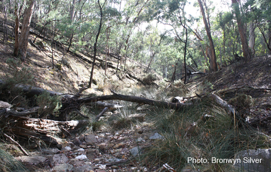
The protective action of moss is easy to see. The following picture shows clearly how soil has been washed away from the area not covered by moss:

Road embankment, Castlemaine: soil has been washed away from the edge of the moss bed.


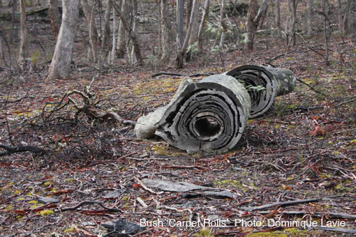
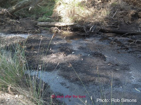
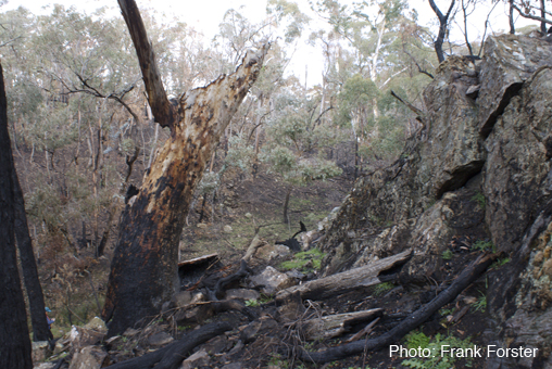
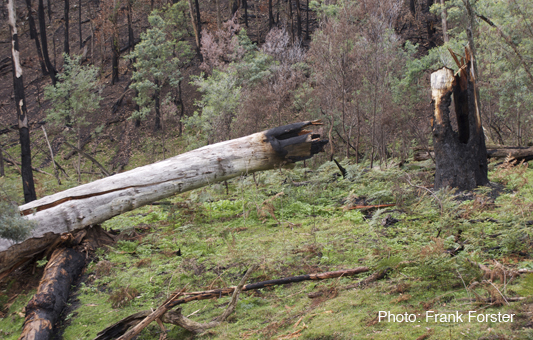
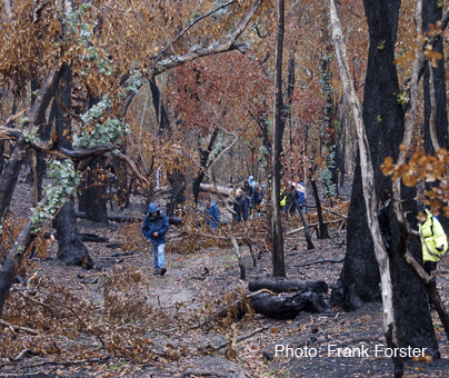
Moss and soil crusts are vulnerable to disturbance by trampling, or fire. Although mosses are not flammable, and therefore cannot be classed as fuel, they are often destroyed by ‘fuel reduction burns’. The following picture tells a story:

Continue reading

Posted in Moss and Liverwort Field Guide group, News | Comments Off on Soil protector: unobtrusive, and undervalued?

Have your say on the catchments

FOBIF has made a brief submission to the North Central Catchment Management Authority on the draft Regional Catchment Strategy 2012-18.

Apart from offering a bit of constructive criticism of some of the language in the document which makes it sometimes hard to read, we have made three specific requests:

–That the strategy incorporate an education program designed to reduce the number of amenity dams in the region. These dams have been shown to significantly reduce inflows to our river systems, and often serve little more than a decorative purpose.

–That the CMA publish easily accessible summaries of the findings of monitoring and research on the condition of remnant vegetation and the effects of management actions. We’ve asked for this because we find official reports often to be over technical and in any case available to a limited number of people.

–That management fire be excluded from steeper sections of the Loddon and its tributaries. Readers of this website will understand why we have asked for this. Given that the Strategy is predicated on positive partnerships between the CMA and other agencies, we see no reason why the Authority shouldn’t exercise some influence in defence of its catchments.

We also expressed lively interest in the upcoming assessments of the Muckleford and Upper Loddon native vegetation assets.

The draft strategy can be found at nccma.bangthetable.com/document/show/51

Email submissions can be sent to haveyoursay@nccma.vic.gov.au


Posted in News | Comments Off on Have your say on the catchments