Take a closer look!

Night sky, Tarrengower. Photo Patrick Kavanagh

The Newstead Arts Hub is hosting a photographic exhibition, ‘Nature in time: images from Central Victoria‘, in March. The exhibition starts on the 5 March and will be open all weekends in the month as well as Labour Day, Monday 14 March.

The formal opening will be on 6 March at 10.30 am. All are welcome and refreshments will be provided.
 
The photographers are Patrick Kavanagh, Bronwyn Silver, Bernard Slattery and David Tatnall. 

You can find out more about the Newstead Arts Hub, the exhibition and the photographers here.

Salters Creek flume. Photo Bernard Slattery

Ironbarks. Photo David Tatnall

Barn Owl. Photo Patrick Kavanagh

Dog Rocks, Leanganook. Photo Bronwyn Silver

Posted in News, Photo Exhibitions | Comments Off on Take a closer look!

Mind-boggling force, rocks that bend

Some people think the world is a messed-up place. I prefer to stay optimistic but, I have to admit, when it comes to the rocks beneath our feet, it’s a pretty accurate view.

These anticlines are just a selection of the crumpled rock strata that make up Castlemaine’s foundations. At least twenty anticlines lie between Castlemaine and Golden Point Road and some have been traced downwards by diamond drilling for at least 500 metres. Anticlines, and their companion synclines, are everywhere.

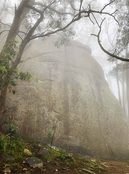
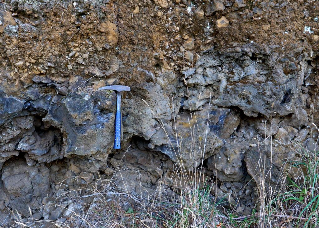
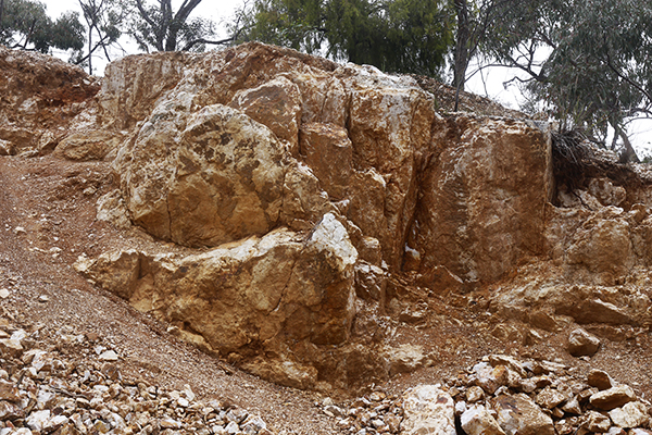
The strata that wrap around these beautiful folds were originally laid down on the deep ocean floor. Back then, some 440 million years ago, mind-bogglingly powerful tectonic forces were messing with eastern Australia by deforming the strata then raising them to form land. It started with a tectonic plate pushing from the east creating folds that run in a north-south direction. Try this with a sheet of paper: anchor one end and push the other towards it and you will see a fold forming at right angles. Most Castlemaine anticlines have sharp, narrow hinges like ‘The Anticlinal Fold’ (Photo 1) in Lyttleton Street but some can be quite broad, especially if there are a lot of thick sandstone beds in the area (Photo 2).

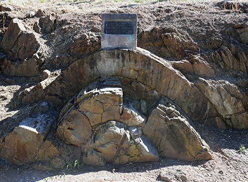
Photo 1: The Anticlinal Fold is fantastic because it shows so clearly the way sandstone layers are bent. Of course, they would have been quite plastic at the time of folding.

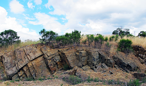
Photo 2: Broad anticline south side of Forest Creek near the Leanganook Track. Just north of Montgomery Street.

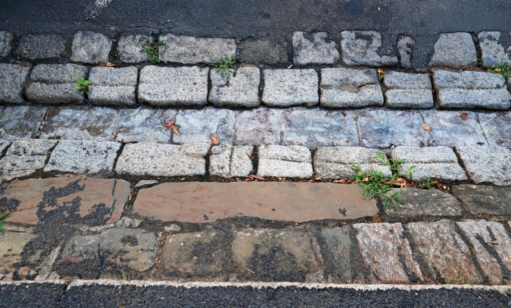
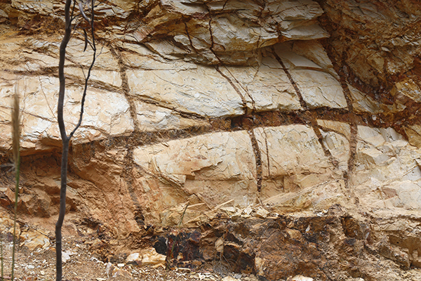
A lesser-known anticline is on the Kalimna Tourist Road (Photo 3) and a forgotten one is in Bull Street (Photo 4).

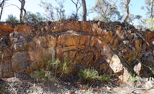
Photo 3: This anticline on the Kalimna Tourist Road is about 700 metres north of the top end of Lyttleton Street. It’s best to look at it from the north side.

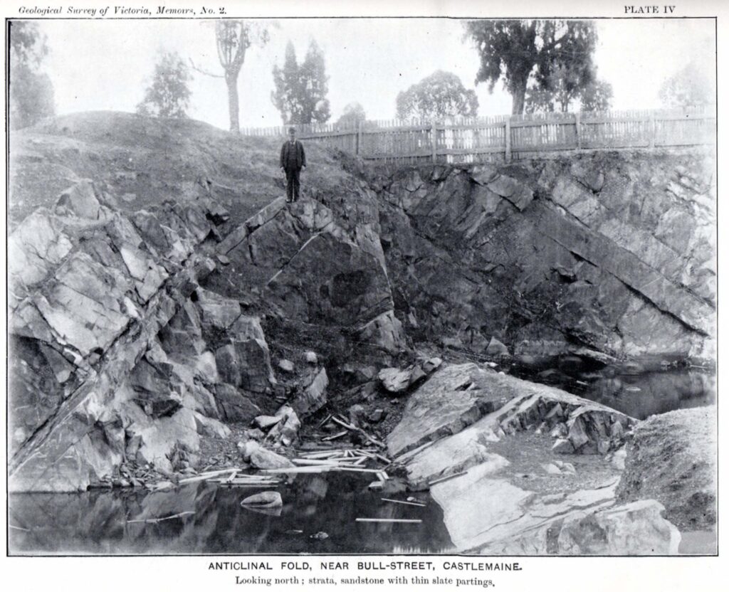
Photo 4: A very nice anticline on the south side of Bull Street about 70 m east of Kennedy Street – it was once a quarry and now is a Council depot. Memoir 2, Geological Survey of Victoria 1903.

This is the sixth post in our geology series written by Clive Willman. 

Posted in Geology, News | Comments Off on Mind-boggling force, rocks that bend

Cootamundra: it looks great, but it’s getting to be a menace

Cootamundra wattles: they’re all over the place. The species is native to a small area of NSW around Cootamundra, but has been planted widely in Victoria. It’s become a bit of a weed, and is capable of suffocating areas of bushland where it becomes dominant. Not only that, but it’s a menace in other respects, too. A new leaflet produced by local plant specialist Margaret Panter argues that it actually harms local wattles by interbreeding with them. The leaflet is below. To get a clearer look, click on it:

Posted in News | 4 Comments

Looking down into the distant past

Geology creeps into everyday life in the sneakiest ways. Take Castlemaine’s gutters and buildings; they exhibit a gallery of local rocks. At Stonemans Bookroom corner, deep gutters are paved with sandstone blocks and a dash of Harcourt granite along the road edge (Photo 1). By adding a sprinkling of basalt around the corner we have three rocks representing the key events in our region’s geological history; sandstone from a vast and ancient ocean floor, a later intrusion of granite (granodiorite to be technical) and lava flows from almost yesterday.

Photo 1: Gutter outside Stonemans Book Room with local sandstone on the inner edge and Harcourt Granodiorite forming the main gutter.

Posting a letter at the Post Office alcove in Lyttleton St gives a glimpse into two successive local metamorphic events (Photo 2). Look down at the magnificent slate flagstones that pave the Lyttleton Street alcove (also the Market building steps). They began as mudstone on the seafloor and later were weakly metamorphosed by heat and pressure, which converted clays to mica minerals. But it took a second dose of heat from the Harcourt granite to finish the job and harden the slate. Everything around the granite was baked hard so that the only decent and durable paving slate is found within 1.3km of its perimeter.

Photo 2: Slate paving in the Post Office alcove. The inset magnifier shows the typical spotted appearance of slates baked by the Harcourt granite. Note the granite has been used as a foundation stone which is common to other major Castlemaine buildings.

In the mid 19th century sandstone quarries were dotted all around the town. The Telegraph Station in Barkers Street, like many of our earliest buildings, is built of local sandstone (Photo 3). It has a beautiful warm colour with fascinating textures derived from its seafloor origins but the rock can become flaky where the clay content is high.

Photo 3: Castlemaine sandstone in the old Telegraph Station, Barkers Street.

This is the fifth post in our geology series written by Clive Willman. 

Posted in Geology, News | 1 Comment

2022 walks program

The 2022 FOBIF walks program is now on the website. The first walk is on Sunday 20 March. All walks start at the Community House in Templeton Street at 9.30am apart from the July 17 Long Walk led by Jeremy Holland which will start at 9am. All members and supporters are welcome.

Posted in News, Walks | Comments Off on 2022 walks program

2022 FOBIF memberships due

Our annual newsletter with this year’s walks program and the 2022 membership renewal form has been sent to Friends of the Box-Ironbark members. For those who don’t receive this in the mail or new members, there is a 2022 renewal/join form here

Posted in News | Comments Off on 2022 FOBIF memberships due

New Year fireworks 110,000 BC: Lalgambook!

Mt Franklin, or Lalgambook, is a volcanic scoria cone with a wonderfully preserved crater. Lalgambook was once thought to be 470,000 years old but a more accurate and surprising date was published in 2013; it turns out to be amongst the youngest volcanoes in central Victoria – a mere 110,000 years old. This is probably way too old to have been witnessed by first nation people, but they certainly witnessed eruptions in western Victoria as evidenced by the Bushfield stone axe, found buried by volcanic ash dated at about 34,000 years old.

Lalgambook would have started with a powerful and impressive display. Deposits along the north flank shows that the initial eruption was highly explosive with fragments of sandstone bedrock ripped up and mixed with scoria. This first unpredictable stage soon transitioned to a steady eruption of gas, ash and scoria fragments. The ash and scoria were thrown high into the air and quickly built the cone – scoria fragments called bombs, now seen along the entrance road, were welded together as they hit the ground. Some of the finer material would have formed an ash cloud that spread eastwards carried by the prevailing winds.

Welded scoria fragments (bombs) of all sizes can be seen along the entrance road to the Mt Franklin picnic area.

Mt Franklin was the largest volcano but several smaller eruption points are closely scattered around the mount. Lady Franklin is on the western flank of Lalgambook and an even smaller cone can be seen on the northeast side. Lalgambook would have been a mighty New Year fireworks display.

Mt Franklin is the tree covered scoria cone and Lady Franklin is the bare cone to the right.

This is the fourth post in our geology series written by Clive Willman. 

Posted in Geology | Comments Off on New Year fireworks 110,000 BC: Lalgambook!

Another year for FOBIF

About 20 members and supporters of FOBIF came to the last Monday’s end of the year BBQ in Walmer. It was an enjoyable evening with great food and lots of laughter. 

FOBIF members will receive a newsletter with the 2022 walks program in January. The program will also be on the website. 

The FOBIF committee wishes everyone a happy festive season and new year! 

Members and supporters of FOBIF at the December breakup.

Posted in News | Comments Off on Another year for FOBIF

Liquid gold!

Quartz Hill is the site of some of the earliest reef mining in the Castlemaine area. Just
2km north of Chewton, it was one of a handful of huge quartz outcrops that demanded miners’ attention. The problem is not all quartz contains gold.

A few canny miners soon realised that of the three main types of quartz, only one was reliably rich in gold. The big outcrops of ‘massive’ or ‘buck’ quartz (photo 1) are almost completely barren and the narrow ‘spur’ veins that criss-cross the adjacent sandstone and shale are not much better (photo 2).

Photo 1: Massive but useless quartz outcrop at the Quartz Hill mine. The heritage site can be found by taking the Quartz Hill Track off Colles Road but be wary: the track has been damaged by recent rains. Alternatively from Chewton take North Street which meets Quartz Hill Track. 

Photo 2: Spur veins of quartz in ancient sandstone.

The miners left those behind for us to see but completely removed the best quartz – this had formed along a narrow fault than runs north-south along the east wall of the open cut. They worked a distinctive gold-rich laminated quartz, sometimes with thin sheets of pure gold. It had formed millions of years ago when a fluid, carrying dissolved quartz and gold, repeatedly seeped along the fault during dozens of separate earthquakes.

Amazingly, remnants of the ancient fluid are wonderfully preserved in tiny microfractures called ‘fluid inclusions’. The fluid can be probed, analysed and categorised by geochemists who find it consists mainly of water with a little CO2 and CH(methane) and often a tiny vapour bubble. Clever laboratory manipulations estimate the temperature and depth of the fluid at the time of deposition. So, 440 million years ago this hot watery fluid deposited its precious cargo at a depth of 10–15 km at a temperature of 300°C.

This is the third post in our geology series written by Clive Willman. 

Posted in Geology | Comments Off on Liquid gold!

Reminder: FOBIF breakup is next week

The annual FOBIF breakup is on at 6 pm on 13 December at Bronwyn Silver’s place, 1036 Muckleford-Walmer Road. All members and supporters are welcome.

BYO
*  food to share, including something for the BBQ if you like
*  plates, glasses, cutlery
*  drinks
*  a chair

Enquires Bronwyn: 0448751111.

Posted in News | Comments Off on Reminder: FOBIF breakup is next week