Tarilta: a revealing clean up

Readers will remember our original report on the destructive ‘reduction burn’ in the Tarilta gorge, with a picture of a choked creek at the Limestone Track crossing. This section of the creek has now been cleared of debris, presumably by DSE, and the works give some idea of soil loss resulting from the burn operation.

The picture below shows the cleaned up crossing:
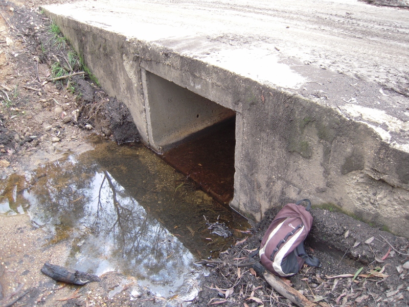
Tarilta Creek at the Limestone Track crossing, May 22 2012, previously choked with washed out soil and ash.


And here’s the same crossing two months ago:

Limestone Track crossing, March 24 2012: soil washed down from the slopes chokes the creek.


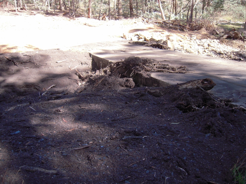
Near the crossing, the soil and ash which has been removed from this small section of creek has been piled into a heap we estimate to be about a metre high, five metres wide and twenty five metres long. This is all stuff which has been washed off the steep slopes of the gorge, and it’s a pile which could be duplicated many times along the creek valley. The damage this soil loss represents to this section of bushland is hard to estimate, but maybe ‘catastrophe’ isn’t a bad word to use.

The works to clear the creek crossing are of course sensible, given that the debris blocking the bridge was a potential flood menace. The clearing of the creek also removes embarrassingly obvious evidence of the damage caused by by the fire. The evidence is still there if you look for it, however.

Posted in Fire Management, News | 1 Comment

‘So what if Newstead is flooded?’

A fascinating collection of old photos of our waterways collected by the Catchment Management Authority gives a bit of a sense of how far things have changed in the last sixty odd years. The picture below of the Loddon river bank upstream of Newstead, for example, shows a bank seriously prone to erosion, with erosion producing activity continuing.

1946 was the year work started on the building on Cairn Curran, in the romantic age of dam building. The project was not without its detractors, however: Newstead councillors expressed the fear that banked up water would flood the town, for example. For their pains they were the object of a tremendous blast in the Castlemaine Mail in March that year from one John Somer: ‘feebleness of brainpower’ was their problem, according to Mr Somer. Newstead was built in the wrong place, he said, seeming to look forward with some enthusiasm to the prospect of the town being flooded.

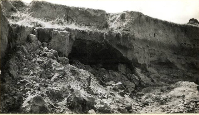
Loddon River bank near Newstead, c 1946: The top four feet, above the dark line, is 'muck, slum and sand' washed down from past dredging operations upstream. The tunneling is prospectors' work.

‘What if it is?’ he asked, before suggesting that everyone would be better off if Newstead was wiped off the map, so that a new, better town could be built on a more sensible site: ‘A new Newstead will arise in all its glory with properly designed alignments and something considerably more elegant in architecture than the higly pigly hotch potch of habitations that now exist.’

Mr Somers’ complacent contemplation of the drowning of Newstead was probably helped by the fact that he lived in Maldon. It’s also a bit hard to understand his negative portrait of a town most people [well, pretty well all people, actually] find very attractive. He did make some interesting points in his letter, however: he suggested that Aborigines, who knew the ‘vagaries of the Loddon’, made their settlements out of reach of floods, and were much more sensible than early white settlers who repeatedly went back to their houses after floods, only to be flooded again a few years later; and his description of the Loddon river flats as being covered with mining debris of ‘muck, slum and sand’ isn’t a bad description of what you can see in the photo above.


Posted in News | Comments Off on ‘So what if Newstead is flooded?’

Trying for cooperation on fire

Members of FOBIF and the North Central Victorian Combined Environment Groups met with DSE officials in Bendigo on Wednesday May 9 to discuss how we might have some more positive influence on the upcoming Fire Operations Plans. It’s fair to say that discussions were positive. The environment groups were concerned principally with implementation of fire plans: that is, it was understood that Government policy was not in question, and that what we were all concerned with was how practice might be improved.

Although FOBIF believes that the five per cent burning target supported by both major political parties is harmful and does little or nothing to improve public safety, our immediate concern is that in implementing this policy DSE is not observing its own code of practice.

Two examples [of many] in recent times are an asset protection burn on Mount Alexander which was allowed through lack of supervision to destroy ten times the target area; and the Tarilta burn which was theoretically intended to achieve ecological outcomes, but was in fact a mindless holocaust.


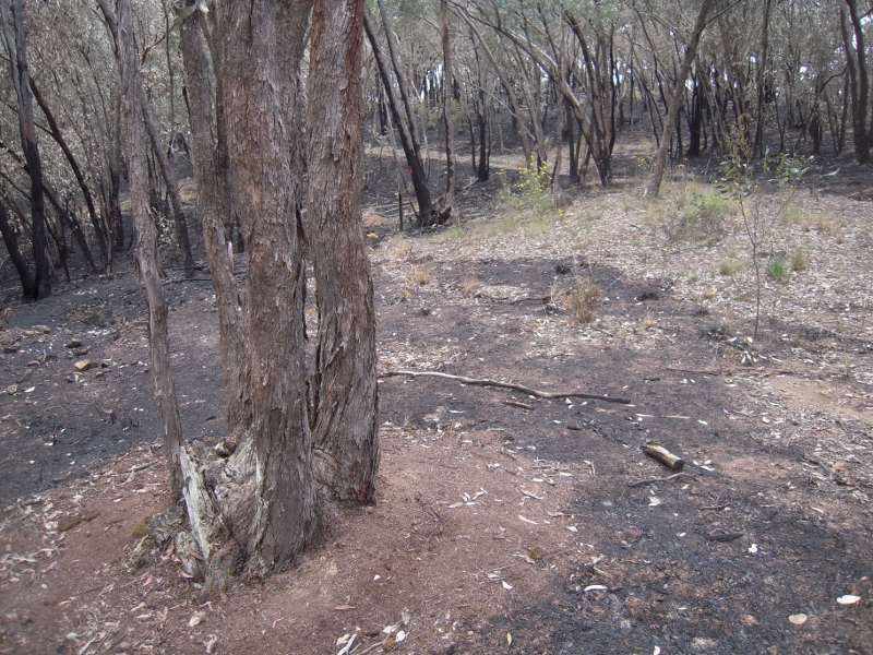
Raked earth around a tree in DSE burn zone, Muckleford forest: this practice is essential to protect older trees, but seems to be done erratically, and there is suspicion that it is done mainly closer to tracks, where damage will be more obvious. Environment groups have asked DSE for maps and documents which would show transparently the detailed planning which is supposed to go into every operation.

Environment groups at the Bendigo meeting tabled a list of documents they would like to see before the next Fire Operations Plans are finalised. The intention of the list is to get some kind of transparency into DSE’s fire practices. We would like to know what the reasoning is behind each burn, and what measures will be taken to ensure that the stated objectives are achieved. We were not promised anything, but were assured that efforts would be made to produce what documents were possible.

DSE staffing around the state, including Bendigo, is understood to have been cut by about 30%. The State Government as given assurances that none of the cut positions is ‘front line’, but this is a shady justification, suggesting that if you’re not ‘front line’, you’re not really needed. The documents listed below are produced by people who are essential to the proper conduct of ‘front line’ operations.

There will be a follow up meeting in June. The ‘wish list’ includes the following:

Continue reading

Posted in Fire Management, News | 1 Comment

What next for the northern catchments?

The Draft 2012-18 Regional Catchment Strategy is now out for public consultation, and anyone interested in land health in this area should be concerned to look over what the North Central Catchment Management Authority will, in theory, be using as its guide to action over the next few years. The draft will be the subject of a series of 10 public meetings in the coming weeks. In our region, the community meeting will be held at Campbells Creek Community Centre at 7 pm next Thursday 17 May.

The draft is quite startlingly brutal in its assessment of its predecessor, 2003-7 Strategy: ‘low level of ownership’ by the community, ‘rapidly outdated’, ‘lack of baseline data’, vague targets and vagueness in assigning responsibility for achieving targets are a few of the criticisms it lists of that now defunct document.

This one aims higher, but its success will depend heavily on the willingness of individuals and groups to have a go. This Strategy tries to be specific, and its approach is to begin by identifying assets in the region which can be clear targets for constructive action.

What are those assets? You can help answer that question by turning up at Campbell’s Creek on the 17th and having your say.

This is a wonderful opportunity to have input into the Regional Catchment Strategy – it’s reviewed every 6 years or so and many things can change in that time. It’s important that the community consultations highlight programs to protect, enhance and connect native fauna and flora: these are important not just in themselves, but as partners in creating the kind of land health which can underpin production.

If the word ‘strategy’ turns you off, there are probably lots of good reasons, over use being one. The draft Castlemaine Diggings NHP management plan some years ago listed as an aim the development of ‘a list of strategies…to develop strategies…!’ The word is often used to cover up a lack of activity: it’s important that the Regional Catchment Strategy doesn’t end up like that.

Details of public meetings, and access to the Draft Strategy, can be found by going to http://nccma.bangthetable.com/.

Posted in News | Comments Off on What next for the northern catchments?

Land restoration: is ‘local provenance’ enough?

About 70 people turned up to Sutton Grange on Tuesday night to hear Melbourne University’s Ari Hoffman deliver a stimulating talk about how landcare groups  might approach revegetation projects to cope with a rapidly changing climate. His talk was the third in the 2012 Connecting Country education program evening series.

Professor Hoffman’s absorbing talk was built on a number of propositions: the climate is changing rapidly—more rapidly than it ever has; the ability of plant communities to cope with change is directly related to genetic diversity; and that, therefore, we can enhance the ability of our vegetation communities to survive rapid change by increasing their genetic diversity.

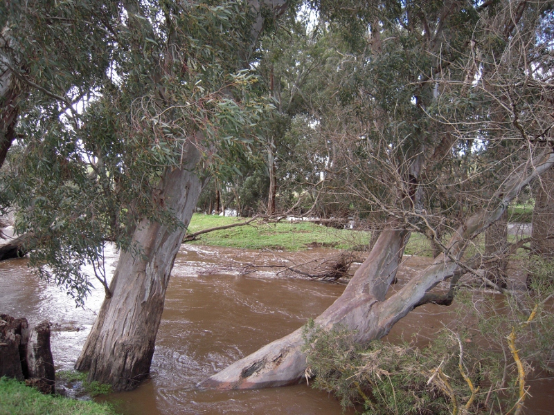
Loddon River near Guildford, September 2010: Professor Hoffman used the example of River Red Gum to suggest that restoration works should use a proportion of plants sourced some distance from the work site, in order to enhance genetic diversity.


Professor Hoffman acknowledged that his argument potentially ran counter to the accepted thinking of Landcare groups and other land restoration practitioners: these currently operate on the belief that revegetation projects should be done with plants sourced from seeds collected locally: that plants having ‘local provenance’ will be best suited to local conditions. Ari Hoffman agreed that this is generally the case, but argued that in times of change, and in situations where plant and animal communities had been fragmented by land clearing and development, isolated populations can lack the degree of genetic diversity which could increase their resilience in the face of change. He suggested that future revegetation projects should use a provenance system roughly divided as follows: about sixty per cent ‘local’; thirty per cent sourced from a ‘medium’ distance away; and ten per cent from a significant distance away. A variety of approaches could be used, depending, for example, on whether a species used wind or birds to disperse seeds.

Professor Hoffman acknowledged that there were risks in this procedure, but noted that some natural hybridisation was common, and that experimental evidence had shown that isolated populations were strengthened by the introduction of new genetic material.

Discussion of this idea was lively, probing and constructive, and the audience stayed for a long time after the talk—encouraged by the presentation of outstanding supper desserts by Growing Abundance.

Posted in News | Comments Off on Land restoration: is ‘local provenance’ enough?

FOBIF poster available again

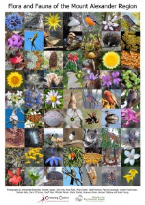
The poster, pictured at left, was produced by FOBIF and Connecting Country late last year. It contains 63 photos highlighting the beauty of our local bushlands. The first edition sold out but there are now more copies available from The Hub 14/233b Barker St (entry through glass door on Templeton Street). The cost is $15 dollars for FOBIF and/or Connecting Country members. The poster is also available from Legion Office Works, Stoneman’s Bookroom and the Castlemaine Tourist Information Centre in the Market Building. Click here to see a larger version of the poster.

Posted in News | Comments Off on FOBIF poster available again

2012 Mamunya photo exhibition

FOBIF’s 2012 Mamunya photo exhibition will be held in Tog’s Cafe Castlemaine from June 7 until July 13.

The purpose of the exhibition, as for its predecessors held in Newstead and Wesley Hill in the last two years, is to ‘honour and celebrate the box ironbark forests of Central Victoria.’ Photos will be selected from the FOBIF website gallery, supplemented by new pictures submitted by local photographers.

If you would like to contribute photographs or have any enquires, ring Bronwyn on 5475 1089 or email us on info@fobif.org.au. We need to have all contributions by 17 May to allow time for framing.

Posted in News | Comments Off on 2012 Mamunya photo exhibition

Change to Walks Program

Due to unforseen circumstances we have had to make a change in the FOBIF walk’s program. Doug Ralph will now be leading the walk to Tarilta Gorge on 17 June and Malcolm Fyffe will be leading his Yandoit walk on 15 July. The 20 May walk in Chewton is unchanged. Check out the walks page on this site for more details.

Posted in News | Comments Off on Change to Walks Program

Mapping Kalimna’s weeds

Following our efforts to persuade authorities to concentrate fuel reduction efforts on areas close to settlement, and to integrate them with weed clearance [see our post Weeds are for burning, Feb 21], FOBIF has proposed a weed mapping project for the township side of Kalimna Park in Castlemaine. The proposal runs as follows:

The natural biodiversity assets of Kalimna Park are under constant threat from human actions:

  • invasion of exotic weeds (boneseed, gorse, blackberry, bridal creeper and garden escapees),
  • pest animals (foxes, domestic cats and dogs)
  • road widening
  • rubbish dumping
  • fire risks

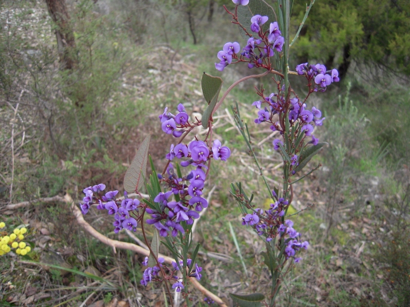
Hardenbergia in Kalimna Park: the Park's proximity to Castlemaine makes it a rich asset, but also presents management challenges.

In addition, because of the Park’s proximity to housing, there is pressure on park managers to apply fuel reduction procedures which may damage the extremely high biodiversity values which persist in this part of the Park.

Aim of the Weed Mapping Project:

To support improved management of the park, a weed mapping project has been designed to identify the areas containing these weeds to assist the volunteer friends and the land manager (Parks Victoria) in their control.

Continue reading

Posted in Fire Management, News, Weeds | Comments Off on Mapping Kalimna’s weeds

Fire: what’s the Code of Practice?

In preparation for the Bendigo Meeting of April 18 [see our post below], Environment Groups were supplied with a briefing by the Environment Defenders Office on the various legal obligations governing DSE’s fire management. The document is printed below, slightly edited, for members’ information:

Fire Management on Victorian Public Land and Community Consultation

This document briefly outlines the legislative basis for fire management on public land in Victoria.  It has a particular focus on the role of prescribed burning and community consultation. It provides answers to the following questions:

  • Who is responsible for fire management on public land in Victoria?
  • What is the Code of Practice?
  • What are they key requirements of the Code?
  • What are the community consultation requirements of the Code?
  • What are the DSE’s biodiversity protection requirements?

The purpose of this memo is to help individuals concerned about the environment to understand how the law surrounding fire management, especially prescribed burning, and what place community consultation holds in this process.

Who is responsible for fire management on public land in Victoria?

The Department of Sustainability and Environment (the DSE) is the government body largely responsible for managing fire on Victoria’s public land.

Public land includes National Parks, State Parks, State forests and Crown Reserves.

The DSE is headed by the Secretary of the DSE, who is currently Greg Wilson.

The DSE’s specific responsibilities are set out in the following Acts:

  • The Forests Act 1958:
    • Section 62(2) states that the Secretary must carry out ‘proper and sufficient work’ for the immediate ‘prevention and suppression of fire’ and for the ‘planned prevention of fire’ in States Forests, National and State Parks, wilderness areas and Crown Reserves.
    • Sections 63 to 69 sets out the Secretary’s general powers in relation to fire suppression and prevention. These include powers to order landowners to carry out burning off activities.
  • National Parks Act 1975:
    • Section 17(2)(b) states that the Secretary shall ensure that ‘appropriate and sufficient measures are taken to protect each national park and State park from injury by fire’ (s17(2)(b)).

The DSE’s fire management responsibilities are balanced by other responsibilities, such as its responsibilities to protect biodiversity, which are set out below.

Continue reading

Posted in Fire Management | Comments Off on Fire: what’s the Code of Practice?