
If you haven’t seen it, get along to the Castlemaine Gallery and check out its Stonework exhibition. This exhibition combining geological exhibits and related works of art offers an intriguing set of insights into our landscape. If for no other reason, it’s worth going just to see the amazing 1853 Selwyn geological survey map of this region (see our previous post on this wonder here ).
The exhibition is described as follows:
‘There are many ways of looking at a stone. For First Nations artists with a deep knowledge of their Country, stones and rock formations have a spiritual and cultural energy as well as intrinsic and material qualities of colour, sharpness, hardness, weight.
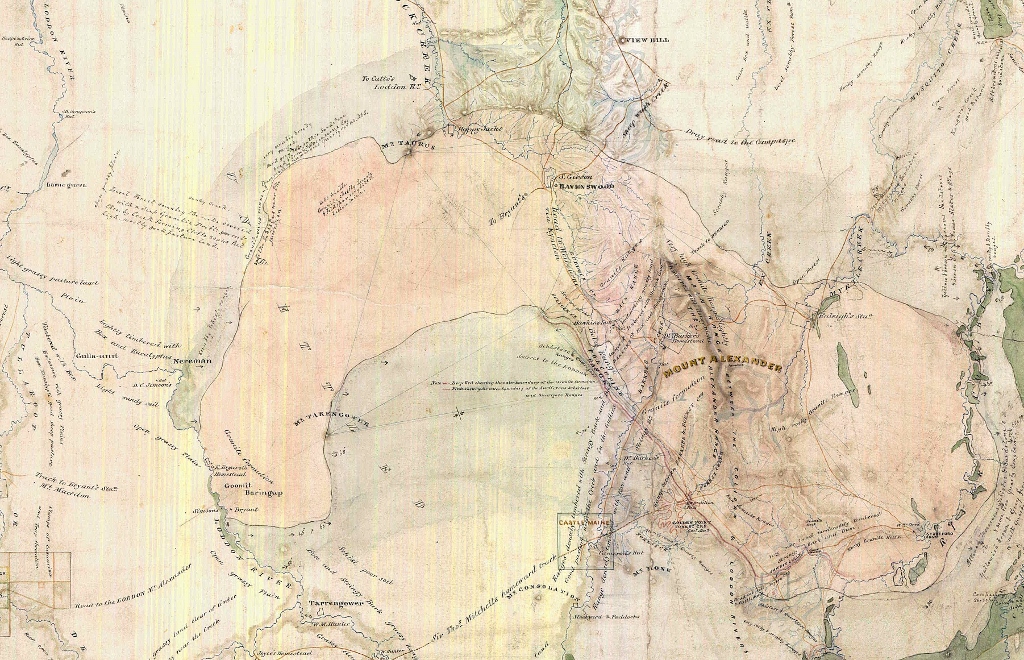
Section of the 1853 Selwyn map. The late Gerry Gill described it as ‘full of quiet calm, still, beautiful’…but also ‘terrible, disturbing’, because it recorded a landscape in the process of dramatic transformation.
‘A different attitude to stones developed in Europe in the 19th century. Sharp-eyed natural historians turned their attention to mountains and valleys and developed a controversial new discipline – Geology. These quarrelsome thinkers challenged the traditional view, based on the Biblical studies, that the Earth was only 6,000 years old. Many artists had a working knowledge of these dangerous new ideas. And with the discovery of gold in the Castlemaine region in the early 1850s, an obsession with faults and seams, uplift and anticline was almost universal in Central Victoria.
‘With rocks in mind, works by Louis Buvelot, Arthur Streeton, Frederick McCubbin, W. B. McInnes, Elma Roach and Penleigh Boyd show landscapes that are dynamic and alive, constantly weathering, warping, folding, eroding, erupting or sinking.
‘Contemporary artists, sculptors, photographers and jewellers also reveal unexpected aspects of rock and stone: geometry, ritual, even relationships to memory and trauma. Contemporary artists include Stephen Bram, Alvin Darcy Briggs, Pete Curly, Brodie Ellis, Sally Marsland and Felix Wilson.
‘The exhibition also includes historical maps: the work of geologists and cartographers from the Geological Survey of Victoria, who in the 19th century meticulously surveyed and mapped both the visible and the subterranean flows of rock and sediment. While in the 20th century, local amateur enthusiasts returning home with pockets full of stones, have created the rock collections which fill the museum cases. Specimens of minerals and fossils ground the exhibition in the physical world and introduce the viewer to the concept of deep time.’


 Click on image for info/order page
 Click on image for info/order page
 Click on image for info/order page

")


")


