
Floods are probably the last thing on anyone’s mind as we endure another heat wave–but it’s a sure thing that they’ll happen again some day. The North Central Catchment Management Authority is looking for ways to soften the blow when it does come, and has run a public meeting and a number of consultations to gauge community feeling about how the three Castlemaine creeks [Barkers, Forest and Campbells] should be managed.
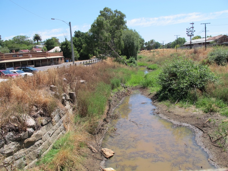
Barkers Creek, January 2014: Even when it’s justified, creek clearance can cause public angst. There’s no evidence that clearance of native vegetation does anything to reduce flood levels.
Here’s a list of ideas thrown up in discussion so far:
–Clear out the creeks (particularly Barker’s creek between Walkers Street and Gaulton Street)
–Levees (particularly investigation of existing levees around the bowls club and National School Lane but also a suggestion to add a levee along the north side of Forest Creek alongside the caravan park from Barker St bridge to the railway;
–Improve local drainage (a large number of suggestions relate to this);
–Retarding basin in Happy Valley to reduce magnitude of flash flooding in urban area;
–Increase vegetation where appropriate to reduce flows entering creeks and to slow runoff divert water to natural retention basins through catchment ‘contour channels;
–Raise houses;
–Flood warning systems; and
–Planning controls to restrict development on floodplains.
All of these ideas present challenges or problems in one way or another. For example:
–Creek clearance: a lot depends on what you mean by this. Occasional efforts have been made to argue that native vegetation significantly raises flood levels. There’s no evidence for this. As the 2012 Waterway Management Strategy puts it: ‘Research has demonstrated that vegetation plays an important role in slowing floodwaters and lowering flood peaks.’ The Strategy points out, however, that some vegetation, like willows, can raise flood beds and worsen flooding.
–Levees: these would need careful planning, or they simply solve the problem in one place by moving the floodwaters elsewhere. The railway line is effectively a levee which has pushed flood waters over towards Gingell Street, for exemple.
–Increase bridge capacities: presumably this means increasing the span of bridges to allow more water to pass beneath them. Flooding often happens when a wide stream has to pass under a narrow bridge. Given that there are several bridges in the town, widening could be expensive.
In other words, there are no cheap and easy solutions. And in the background of this discussion there is the amazing fact that 120 years after the disastrous 1890 floods we have no accurate idea of flood levels.
DEPI and the NCCMA have already proceeded to some vegetation management along Barkers and Campbells Creeks, and this has caused angst in parts of the community. The moral of this is that whatever solutions are adopted need to be carefully and clearly argued to the public.
We’d be interested in any ideas readers might have. Alternatively, you can write to the person in charge of the NCCMA consultations, Shaun Morgan: Shaun.Morgan@nccma.vic.gov.au


 Click on image for info/order page
 Click on image for info/order page
 Click on image for info/order page

")


")


In our small ephemeral creek, I have tried to mitigate the erosion and gorging away of soil that floods can create by strategic planting and placing of logs to slow the run-off of water. This has had the added advantage of allowing water more time to soak into the soil and improve our soil quality. Floods are a natural way to replenish soil fertility. On our property we ensure some protection by keeping infrastructure off potential flood sites. So some adjustment to planning regulations that secure housing by preventing building on floodplains, could free up these areas for use as public amenity in non-flood times, such as strategic wetlands for holding excess water, walkways, passive recreation and maybe even community gardens that may benefit from the soil and silt brought in by floods.
I wonder what others think?