
Muckleford Map-Clive Wilman
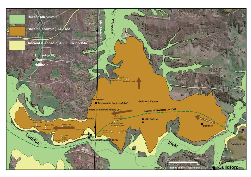
On a perfect (except for the lack of rain) autumn day walkers arrived in convoy on a private property to learn about the geological history of the Muckleford Gorge from geologist Clive Willman, assisted by Ross Cayley from the Geological Survey of Victoria. While Clive told the story of 480 million year old sediments being laid down in a deep ocean, then subsequently being crushed by sideways pressure, which folded them into tight parallel folds and raised them to form land. The walkers marvelled at the spiky rocks sticking vertically out of the ground at the top of a very steep-sided valley, the Muckleford Creek far below. Ross added the even bigger picture story, of tectonic plates and convection currents moving over the earth’s surface as the driving forces behind the movements. The descent to the creek led to a site where Clive introduced a main player in the gorge’s story – the Muckleford Fault, formed during the period of intense folding and still active today. We observed rocks that lay in the Fault’s zone of influence, showing cleavage features that cut across the sedimentary layers, and learnt this was in the Fault’s hanging wall. The mystery deepened. A delightful walk beside the creek led to a large grassy mound where morning tea was enjoyed, while Clive opened our eyes to the fact that we were sitting on the debris from a large landslide. Part of the valley side had broken away and slid downhill. More material could be seen on the far bank. Clive speculated that this was the result of an earthquake brought about by a large movement of the Fault. By this time people were aware that the far side of the valley was composed of basalt lava that had flowed along the old valley a few million years ago, shifting the creek to its present position. A further walk along an open valley floor, a creek crossing, then a traverse of steep ground brought us to a large mullock heap on the hillside. Here Clive spoke about the gold-bearing gravels that lay in the ancient creek, before the basalt covered it, and methods used by miners to exploit it. A final descent to the creek led to a grassy bank with convenient shade for lunch, before a long steep ascent back to the cars. The view from the top, as we emerged onto flat, open ground was magnificent and a final stretch through open woodland was a fitting end to a very special experience. Grateful thanks to owners Ian and his mother, and to our expert guide Clive Willman. You can read the walk notes here.
Christine Henderson
Thanks to Liz Martin for the photos


 Click on image for info/order page
 Click on image for info/order page
 Click on image for info/order page

")


")


