Weed Fact to ponder on
As a follow up to our item on gazanias last year [see News Archives]: weeds cost Australian Agriculture $4 billion a year in lost productivity and management costs. 65% are escapees from gardens and parks. This is of course separate from the damage they do to biodiversity. For more info: www.weeds.gov.au
How dangerous is forest fuel?
DSE has just released its Overall fuel hazard assessment guide [Fire and adaptive management report No 82]. You can request a copy from http://fireweb.dse.vic.gov.au/argus .Among other findings: it’s the arrangement rather than the quantity of fuel which affects whether it’s dangerous. An example: a few pages of a newspaper crumpled up are more dangerous than a heavy book. More details on our website soon.
Application to VCAT on 7 Lot Subdivision
FOBIF has requested VCAT to review a decision by the MASC to grant a permit for a 7 lot subdivision in high conservation bush at Diamond Gully near Castlemaine. The permit would allow the destruction of biodiversity values in over half of the 7 ha of bush.
The bush at Diamond Gully has been classified as high conservation by a council funded report, as a nesting and foraging site for the threatened brush-tailed phascogale.
VCAT has recently made a “guideline” decision that for subdivisions where there is high conservation vegetation, the starting point for the subdivision design is the avoidance of clearing of the vegetation. With the Diamond Gully subdivision, there is 4 ha of already cleared land where the building envelopes could be sited rather than in the forest.
Uncommon Beauty Conceals a Deadly Trap
Carnivorous plants can trap prey in a various ways: pitfall traps, flypaper traps, snap traps and lobster-pot traps. The well-known local carnivorous plant Scented Sundew Drosera whittakeri uses the flypaper trap method. Insects are captured in the sticky dew exuding from hairs growing on its leaves.
Another trapping method is the 'bladder trap' and the intriguing Utricularia dichotoma is one of the carnivorous plants that uses this method. This 'bladderwort' is commonly known as Fairy Aprons due to the appearance of its flowers.
Fairy Aprons have a tiny 'bladder' which is small and submerged under water or in damp soil with a hair-triggered door that responds within 1/30th of a second to suck in any passing insect. The vacuum-driven bladder has been described as the most sophisticated carnivorous trapping mechanism to be found among plants. The violet flowers are tiny and grow on a thin stem.
Doug Ralph recently discovered scores of Fairy Aprons in a swampy area in Harcourt not far from Mount Alexander. Several days later three FOBIF members accompanied him to see and record the sighting. Although none had seen them before, Ern Perkins from the Castlemaine Field Naturalists reported that bladderworts have been previously been recorded on Mount Alexander, and also on some of the wet granite areas in the Harcourt-Sutton Grange area.
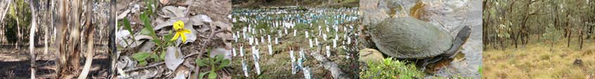
After the burn off
FOBIF members have made several visits to the south end of the Diggings Park to monitor the effects of a very severe management burn conducted near the Wewak track in Autumn last year.
On our latest visit, on February 7, we came to the following tentative conclusions:
1. Recovery of species has been good. Good rain has provided excellent recovery conditions, and we will report on the detailed monitoring of the area by Castlemaine Field Naturalists in due course, as well as DSE monitoring, if any. There has been an outbreak of thistles, a lot of which we’ve pulled out and taken away, and dandelions, possibly because of the large areas of bare earth created.
2. Because of the severity of the burn, there are plenty of dead trees, some of them quite big. The evident intention of DSE operatives seems to have been to burn the bark from the many stringybarks in the area, but we can’t believe it was DSE’s intention to create thousands of eucalypt seedlings [see photos in our gallery archive ]. It seems that in a very short while there’ll be a more dangerous fuel load down there than there was before the burn, and the tree cover much denser than is desirable, ecologically speaking.
3. There’s been some erosion, more than on the unburned areas down that way, and there’s still a fair bit of bare ground.
We are currently negotiating with Parks Victoria to have a joint visit to the area to get their opinion of what has been achieved in this operation. This is of particular importance to us given that burns on the adjacent Limestone track and around Smutta’s track [on the other side of the Loddon River] are DSE’s program. Both of these areas are much steeper than the Loop track area: and we have already had occasion to worry about DSE’s procedures in this area [See ‘Burning concerns’ and ‘A gap in the records’ in our News Archive]
Mamunya Photo Exhibition and the State Festival
FOBIF's exhibition of photos of local flora and fauna, 'Now Look Here' will be showing at the Bold Cafe in Wesley Hill during the State Festival this year. See the Festival program for opening details.
The Swift Parrots of Muckleford” – DVD launch
The Castlemaine Field Naturalists , the Norman Wettenhall Foundation and The Melliodora Fund are launching The Swift Parrots of Muckleford DVD on Thursday February 24 at 10.30 am at The Castlemaine Market Building, followed by morning tea. Chris Tzaros from Birds Australia will speak. See www.swiftparrotsofmuckleforddvd.com for more details. RSVP to Beth Mellick on 54 721316 or beth@nwf.org.au by 17th February— numbers are limited.